Penobscot Bay—Churning Waters, Changing Tide
Abundance and exploitation, culturally divided, and rich with opportunity
By Tom Groening
It’s the largest estuary on Maine’s 3,500-mile-long coast, lying at the mouth of the storied river and watershed that bear its name, which in turn was taken from the native people who even today advocate for its ecological health.
More than 400 years ago, Penobscot Bay drew European fishing boats which harvested its plentiful cod for mouths back home. The history of resource extraction continued, from finfish to lumber to granite to lobster.
Boatbuilders and fishing fleets have dropped anchor at its many coves and natural harbors, and recreational boaters as famous as Walter Cronkite and Ted Kennedy have said it offers the world’s best sailing. Its cultural characteristics range from the tourism-focused Rockland and Camden on its western shore, to an industrial port at Searsport and a long-time paper mill, recently closed, at Bucksport at the top of the bay, to the world’s largest lobster-landing port at Stonington on its eastern edge.
And Penobscot Bay is home to several of our year-round island communities—Isle au Haut, Islesboro, North Haven, Vinalhaven, Monhegan, and Matinicus.
The bay’s story begins with its physical characteristics, visible on a map, but also includes forces below the surface of its waters. It is a story of remarkable abundance, of exploitation, and of disruption. And even as global forces buffet its communities with warming waters and rising seas, the next chapter may be marked by opportunity.
The biological abundance can be attributed to Penobscot Bay’s configuration, and to the waters that feed it, both freshwater from the north and saltwater from the south. In short, the bay is nothing like a stagnant pond.
The Penobscot River is New England’s second largest (after the Connecticut), and the watershed drains nearly one-third of Maine—some 8,750-square miles, according to NOAA. Penobscot Bay is the second largest in the Gulf of Maine after the Bay of Fundy.
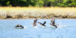
Nutrients from the river feed the bay, and the 11 diadromous, or sea-run, fish that return to and leave the Penobscot River provide food for other species.
A circulatory pattern also contributes to the abundance. The Gulf of Maine Gyre carries water westward from the open ocean to the lower part of the bay near Matinicus, and when it meets a rising tide, a strong “drift” up the western side of the bay results. Fourteen-mile-long Islesboro divides the upper bay west and east which creates a clockwise circulation around the island, if the top of the clock face is at Searsport.
Scientists and keen on-the-water observers like Bob Steneck, Ted Ames, and Robin Alden refer to the various oceanographic phenomena as the “well-mixed eastern Maine coastal current.”
Steneck, a professor and researcher at the University of Maine’s Darling Marine Center, shows a color-shaded map of the Gulf of Maine in his presentations on the region, with green tones corresponding to warmer waters, blue for cooler. A sharp delineation between the two colors extends south into the gulf from the line of Penobscot Bay’s western shore.
“There’s a kind of wall right here,” he says, gesturing to the line. “This is a transition zone. It’s a pretty significant transition zone, oceanographically,” and it affects animal and plant life. “It’s a biogeographic shift that happens right at Penobscot Bay.” Marine species are split at that line, he says.
Ames, a respected observer of the bay whose expertise comes from a science and research background, along with fishing experience and a family heritage, says that complex current “tends to trap critters.”
“It’s a place of huge complexity,” says Alden, who with her husband Ames founded the Maine Center for Coastal Fisheries and who is a former state marine resources commissioner. “You think of a bay as being the place where a river opens out, but the oceanographic work that’s been done shows there’s a lot more going on. There are several circulatory patterns.”
One kind of critter important to the bay is plankton, Alden says, and it gets dumped there in great numbers. Ames and Alden go deeper in explaining the abundance.

Ted Ames and Robin Alden
“Initially, it had extensive eel grass areas,” he says, “extensive nursery habitat. It had not only huge spawning areas for prey species like herring, it also had the whole productivity of the Penobscot River and the diadromous species that come out of there as juveniles every year. Just an abundance of prey.”
Before dams were built on the river, even more fish were in the mix, Alden notes.
How good was the fishing? Steneck cites the English explorer James Rosier, who wrote about “sailing up the Penobscot” in 1605 and recorded seeing “great cods and haddocks, which gave us a taste of the great plenty of fish … wheresoever we went upon the coast.”
Steneck says declines in landings began in the river and estuary in the 1840s, followed by declines down the bay through the 1880s, all due to overfishing. Perhaps surprisingly, mackerel was the most valuable species harvested from Penobscot Bay in 1880, amounting to about 40 percent of the catch.
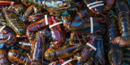
“Now, it’s 92 percent lobster. We’ve fundamentally shifted the ecosystem to lobster,” he said. Few cod to eat the larval lobster, and more seals may mean more juvenile cod are consumed, removing that predation.
Ames remembers his father telling him about his early years fishing.
“He had always said, ‘We did between 10,000 and 20,000 pounds a day.’ And they pursued cod all the way up to Stockton Springs. That’s incredible.” That abundance continued. “When I started fishing—early 1960s—the first few years I went, we handlined. We averaged 750 pounds of fish per man per day.”
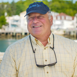
Paul Anderson
Courtesy: Maine Center for Coastal Fisheries
Ames and his brother then began tub trawling, fishing five tubs, “and we averaged 1,000 pounds of dressed hake a tub. We did that well until 1966, ’67, when gill netting began. Fishermen were going out with ten nets and filling their boats.”
And that’s when Penobscot Bay’s story evolved from abundance to exploitation. Where did regulation go awry?
Alden, the former marine commissioner, has a ready answer: “Not recognizing that control of technology is absolutely essential. As a fisherman told me years ago, ‘We declared war on fish and we won.’”
Paul Anderson, executive director of the Maine Center for Coastal Fisheries, was working for Alden at the Department of Marine Resources back in the 1980s and remembers accompanying her to a meeting with fishermen in Rockland.
“I remember one fisherman getting up there and saying, ‘Jesus Christ, when we was fishing hard here with my dad and uncle, we’d go out in the bay off here and we’d fill the boat to the gunnels with redfish and be back before noon. I want to know where those goddamn fish are!’ And my reaction was, ‘Well, maybe you should have left a few of them.’”
Anderson agrees with Alden on the role of technology, with “new gear that was too efficient for the fishery” taking its toll. “There was no sense of nurseries, there was no sense of the history and that you’ve got to take care of these populations.”
A central principle for the MCCF is that species must be managed granularly, almost to the point of allowing harvesting in one cove and not in another.
“Fish go to specific places for specific reasons in their life cycle,” Alden notes. “If you take them at the wrong time in their life cycle, you can wipe them out.”
Ames remembers a productive spawning ground for herring near Matinicus, now gone. “The enormous productivity has disappeared. Now we’re in lobster city.”
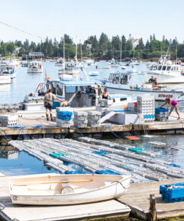
Vinalhaven’s working waterfront has one of the largest lobster landings in Maine, bringing in 7.6 percent of the state’s product in 2019.
If lobster city had a mayor, it might be Dave Cousens. Cousens served as president of the Maine Lobstermen’s Association board for 27 years (and also serves on the Island Institute’s board of trustees). He started fishing off South Thomaston in 1967 at age 10 and is still at it.
Very much a citizen scientist, Cousens has kept careful records of water temperature, signs of the molt, and landings for those many years.
“I started that in 1980,” he says of marking the day on the calendar when shedders showed up in his traps. “It was consistent until 1991, ’92.” Shedders would show up within two days on the calendar for most of the 20th century, he believes, right around July 20.
“When we got to ’92, things started going haywire. The temperature here has increased by 4-5 degrees Fahrenheit in the last 40 years. Which is huge.”
When Cousens started fishing, there was more than lobster.
“It’s changed. It used to be lots of fish,” with haddock, halibut, redfish, and cod showing up in his traps. No more. The lobster larvae survival rate was about 1 percent, now it’s 2 percent to 2-1/2 percent, he says.
Landings increased in the 1990s to 35-40 million pounds, and then spiked up to 130 million pounds in 2012. And water temperatures, which only hit the high 50s in the 1980s, began creeping into the low 60s by the Fourth of July in the 1990s.
“By the 2000s, it was consistently in the 60s,” right through mid-September, and now at that level through mid-October, “which is crazy.”
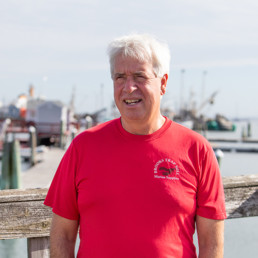
Dave Cousens
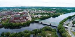
Penobscot Bay is more than a fish tank. It is rimmed by three counties, with two county seats on its shore. Yet while its many towns describe themselves as being on this singular bay, the region doesn’t see itself as a whole. And the region is shifting, west and east.
“In my working time, starting in the early ‘70s,” says Alden, who was then launching and operating Commercial Fisheries News, “I’ve seen the western side of the bay become almost suburban. In the ‘70s, I was in Camden all the time, talking to fishermen,” a scenario that seems unlikely today.
Access to the working waterfront seems to be holding steady, says Anderson, but that could change fast. Affordable housing has diminished, if not disappeared, in shorefront towns. Cousens says if not for his land holdings, in the family for 200 years, his children wouldn’t have homes near the shore.
Anderson describes the effort made to form the Penobscot Bay Network.
“We had several conferences. Sears Island was a galvanizing issue at the time, the possibility of that developing into a shipping port. As we did this, we tried to tell Castine and Belfast that they share this watershed. Or knock at the door of businesses and leaders in Bucksport, and say, ‘You guys share this wonderful, challenging place with Port Clyde and Castine and the islands in between.We couldn’t get anyone’s interest, try as we might.”
Alden argued for establishing a Penobscot baykeeper, to no avail, yet she understands that “time and distance issues” tend to keep west and east disconnected.
“I’ve been really outspoken about this over the years,” she says. “When you have a Penobscot Bay meeting, where do you have it? On the west side of the bay. Increasingly, fishing is not the mainstream of many of these towns. These are fundamental changes.”
And more changes loom. An array of floating wind turbines is in the works for the southern reaches of the bay, a plan strongly opposed by many in the lobster fishery.
Alden and Ames have slightly different takes on the matter.
Yes, climate change is a threat, she acknowledges, and renewables are part of the fix, but the scale is “classic industrialization. ‘Oh, there’s a place, there’s nothing happening there. We’ll put our oil refinery there.’”
Ames characterizes it as “tricky stuff,” and believes “fishermen do have credible concerns,” the greatest of which may be the vibrations and frequencies the turbines create.
Anderson sees the turbines as inevitable.
“It’s going to happen in some way, shape, or form, so it’s important the working waterfront be there at the table to influence it in some way. I think the industry has a lot to share in terms of knowledge, both in site selection and how something like that can be managed in the long term.”
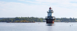
An often-overlooked characteristic of Penobscot Bay is its shipping port at Mack Point in Searsport—two docks, liquid and dry—and an oil terminal at Bucksport. David Gelinas, president of the Penobscot Bay & River Pilots Association, is one of several trained pilots who board ships off Matinicus and guide them up the bay.
“I have been piloting the bay for 29 years now,” he says, and he has witnessed a change in cargoes, though most are still petroleum products—gasoline, diesel, home-heating oil, asphalt, kerosene, No. 6 oil, and jet fuel.
Gelinas has noticed a decline in the heavy No. 6 oil coinciding with the natural gas pipeline coming into Maine from Canada.
“Heating oil also seems to be on a decline, as consumers switch to heat pumps,” along with propane and natural gas.
New cargoes include kaolin clay slurry—used in papermaking—from Brazil, and wind turbine parts. “Recently, we began receiving shipments of wood pulp from northern Europe,” and scrap metal began being exported.
“A significant amount of cement is still exported by barge from Rockland,” he adds.
Gelinas also asserts that in his time, moving oil on the bay has become much safer, with double-hulled tankers going from concept to the norm. Extensive training and digital navigation equipment also are part of the equation.
When—or if—floating wind turbines are moored in the bay, ship traffic may increase, observes MCCF’s Anderson. Aquaculture, too, may be a new growth marine industry. But in the last hundred years, Penobscot Bay has never been a sleepy backwater. It’s just the activities that change.
Ames remembers his grandfather, a lighthouse keeper. “He was stationed on Saddleback Light,” between Vinalhaven and Isle au Haut. “He’d say, ‘In the ‘20s, it wasn’t unusual to have a hundred sails in sight during a given day.’ But he dissed them by saying, ‘But they were only fishermen.’”
Tom Groening is editor of Island Journal and The Working Waterfront. He lives in Belfast.