Fishing, Fowling, and Navigation
How a colonial ordinance shaped a coastline
By Rebecca Pritchard
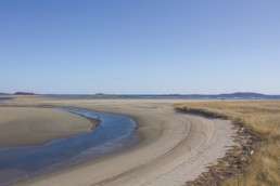
In this part of the world, the tide comes in and the tide goes out twice a day. Each time the tide goes out, it exposes cobbles, mudflats, tidepools, rockweed, and cool wet sand.
Who owns this intertidal zone depends on the law of the land on which the tide ebbs and flows. In New Hampshire, you could walk anywhere below the high tide line along the 238 miles of coastline and never encounter private property.
Like most coastal states, the intertidal zone on the New Hampshire coast is in the public trust, like the ocean itself. In other words, the land between high and low tides is owned by the state, for public use.
In Maine things are different: intertidal land can be privately owned. Why this is so, we’ll get to in a minute. But first, it’s about to get more complicated.
Even on privately owned intertidal land, you may still have a right to be there, but that right depends solely on which activities you engage in while you are there. In Maine, the public has rights to the intertidal zone for fishing, fowling, and navigation.
If that list sounds antiquated, it is. Yet per Maine statute, no one can stop you from casting a fishing line into the water, digging for clams, or shooting a duck (in season) from their private intertidal land, if you can get to it without trespassing. You have the Massachusetts colonial government to thank for this right.
Colonial Influence Remains
The story of how Maine came to have this statute regulating public access to tidal areas can be traced back to before Maine became a state, when it was a territory of Massachusetts. It must be noted up front that this history has been studied almost exclusively by lawyers and judges, due to its impact on public access rights and private landowners’ rights.
Massachusetts passed an ordinance in 1641 and revised it in 1647, which listed all the laws of the colony. The revised 1647 ordinance was entitled, “Laws and Liberties of Massachusetts.” This was a more than a century before the Boston Tea Party and talk of declaring independence from England.
Massachusetts borrowed most of its ordinance from English common law, which specified that the crown owned navigable waters for the benefit of all.
The English, in writing their own common law, had borrowed liberally from the Romans. In the words of Roman law (Justinian Code, 530 AD): “By the law of nature these things are common to all mankind—the air, running water, the sea, and consequently the shore of the sea. No one, therefore, is forbidden to approach the seashore…” The seashore itself was defined to include “as far as the greatest winter flood runs up.”
As George M. Cole pointed out in his 1997 book Water Boundaries, the Mediterranean Sea didn’t have much daily fluctuation in tide. So the Romans defined their coastal boundary according to its seasonal fluctuations, not the daily highs and lows.
Taking a cue from the Romans, the British included intertidal land in their definition of “navigable waters.” Therefore, everything below the high tide mark was owned by the Crown and available to the public, according to English common law.
One detail the Massachusetts colonists did change from English common law was that a landholder’s property extended down to the low-tide mark, not the high-tide mark.
To make up for taking land away from the crown and thereby the public, the ordinance granted the right to “everie [sic.] inhabitant… have free fishing and fowling… so far as the Sea ebs and flows.”
Some historians and lawyers have said the people of Massachusetts moved the boundary of private ownership from the top to the bottom of the tidal range in order to encourage the development of docks and wharves. In a time when most transportation, commerce, and trade traveled over water, docks were crucial.

According to lawyer David Slade, before the colonial ordinance was passed, coastal landowners who wanted to build a dock over land and waters owned by the Crown had to get permission from the colonial government and court. Few colonists requested permission, because they did not have the money to build a structure that would become property of the crown.
Slade wrote in a 2007 document prepared for the Maine Seaweed Council that colonial landowners on the coast petitioned the local government to fund the construction of wharves. Lacking the money for such “public works products,” Slade wrote, the Massachusetts colonial government decided to deed the intertidal land over to the upland property owners, in the hopes they would be encouraged to build docks on their own land.
The Massachusetts ordinance remained in effect until 1774 when the colonies cut ties to the British crown, leading up to the 1775 battle on the village green of Lexington and the subsequent Revolutionary War.
Following the war and Massachusetts’ statehood, new laws were printed in 1814 under the title “Ancient Charters and Laws of the Colony and Province of Massachusetts Bay.” As implied in the title, the laws of the old colony were transferred to the new state government.
When Maine became a state six years later, legislators met in Portland from May 31 to June 28, 1820, enacting the laws that would govern the new state. Having already been living under Massachusetts law, “the state and judiciary adopted everything whole cloth,” said Agnieszka A. Dixon, a lawyer with Drummond Woodsum, who wrote a 2012 article entitled “Fishing, Fowling, and Dockominiums: Maine’s Need for a New Approach to Public and Private Intertidal Rights.”
Dixon said in a recent interview that there was “no direct consideration” of individual parts of the ordinance. “They took the laws” of Massachusetts and therefore “inherited the colonial ordinance.”
To this day, “fishing, fowling, and navigation” are listed as public rights on intertidal land by Maine statutes.
New Hampshire and most other coastal states define private ownership as beginning at the high-water mark. Intertidal lands, like the ocean, are in the public trust. According to the Surfrider Foundation, some coastal states like North Carolina go further, extending public trust land from the ocean to the vegetation line, giving the public access to the entire beach, not just the wet sand part of it.
In Maine, a proposed bill to put intertidal lands under state ownership and in the public trust died last summer after it was receded in the House. Among written statements made in opposition of the proposed bill (LD 1323), Bundy Boit of Penobscot wrote, “The takeover of the intertidal areas by the state is in direct opposition to the law as it has been stated since Colonial times.”
Thus, the law governing the public’s right to intertidal land still takes what Dixon calls an “activities-based” approach. When disputes arise, the old colonial ordinance is what judges refer to.
“Fishing, fowling, that’s what the courts have focused on,” said Dixon. “I think that the [current] law is made by our judges more than anything else, because they’re the ones interpreting these dusty old documents.”