Along the American Archipelago, Signs Are Everywhere
Rising seas, warming waters impacting islands in Alaska, the Carolinas, the Chesapeake
By PHILIP CONKLING
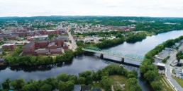
When Maine islanders meet islanders from other American coastlines, you might notice a bit of deference in the air. Maine’s 15 year-round island communities have standing around the country, in part for having persevered while so many others have gone extinct elsewhere.
To add to Maine’s island luster, our island communities also have an impressive history of building elegant and durable boats, from which we harvest more than 700 million pounds of seafood each year.
Maine islanders also have gained national recognition—a front-page story in the New York Times, for instance—when ratepayers on the Fox Islands voted overwhelmingly in favor of erecting three wind turbines on a Vinalhaven hilltop that would produce enough electricity to supply that island and neighboring North Haven’s annual energy needs. According to many islanders, the 2008 vote had more to do with economics than green energy or climate change concerns.
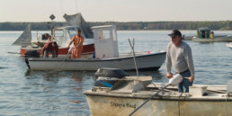
But when Maine island lobstermen began reporting the appearance of marine species from southern waters in their traps—black bass, blue crabs and even sea horses—some fishermen began to wonder whether warming ocean temperatures might increase the incidence of shell disease that had decimated lobster fishing in southern New England.
Ocean warming seemed more pressing after 2012, when Maine lobsters shed their shells three weeks ahead of their normal time after a freakishly warm winter, and nearly paralyzed the industry because the markets could not absorb them. Then two years ago, scientists at the Gulf of Maine Research Institute confirmed that the waters of the Gulf of Maine are warming faster than 99 percent of the rest of the world’s oceans.
What Are They Seeing?
Islanders, I thought, are important witnesses in the front row of climate change, and their attitudes, responses—and adaptations—could be helpful to other Americans. With this in mind, I started visiting and writing to other islanders around the coasts of the U.S. to ask not just about warmer ocean waters, but also about whether they had experienced rising sea levels, storm surges, or other signs of a changing climate. They had.
Around the mid-1990s, fishermen fishing the cool waters off Hatteras Island on the Outer Banks—part of a sinuous chain of sandy barrier islands that stretch for 200 miles off the southern Virginia and North Carolina coasts—started catching fish with sores. Crab potters started talking about pulling up dead crabs and crabs swimming high up in the water column from a lack of oxygen in the water, recalls long-time Hatteras Island resident and writer Susan West, whose husband is a commercial fisherman. “We used to have a straight bass or rockfish catch, but it’s probably been over 10 years since one has been caught,” she said. “That’s a huge change. I have to believe it has something to do with the temperature of ocean water.” The water, she said, used to be cold, but it’s not anymore.
Flooding caused by a nor’easter pushes water on both sides of the bulkhead in Tylerton, one of three communities on Smith Island, Maryland.
(Photo: Dave Harp/Courtesy Bay Journal)
Noongwook, a member of the Alaska Eskimo Whaling Commission from St. Lawrence Island, is worried about warming ocean temperatures in the Arctic. I met Noongwook at a conference of native Alaskan members of the Marine Mammal Commission at Bowdoin College in 2013, and listened to his accounts of the effects of rapid climate change, including earlier spring ice melt and later fall freeze-up, which result in thinning of ice at unexpected times, along with an increase in unpredictable violent weather. Having more and more days of open ocean is a double-edge sword: Last year, Noongwook was part of a whaling crew that landed its first bowhead of the season on March 27—earlier than ever before in the native people’s history. However, more days of open ocean means St. Lawrence islanders also must adjust to a rapid increase in large marine transportation vessels transiting the Bering Strait for commercial purposes.
But Who Is Noticing?
Even as warming ocean temperatures dramatically affect the day-to-day lives of fishermen and hunters, most of the rest of us—on islands or elsewhere—barely notice. We do, however, occasionally notice sea level rise, driven in part,
scientists tell us, by “thermal expansion” from a warmer and thus larger ocean, but also from the additional water from melting ice caps in Greenland and Antarctica. Watching sea level rise can be like boiling the proverbial frog in incrementally warmer water—the frog doesn’t know it is in trouble until it’s too late.
Sea level rise has become an intensely political topic in places like the North Carolina coast where lawmakers, concerned that scientific forecasts may damage economically powerful tourism and real estate industries, passed a law in 2012 requiring future sea level rise projections be based only on observed rates of the past three decades. Several scientists on the state’s advisory coastal research panel resigned from the panel in protest, but the law stuck.
Karen Amspacher, a native of Harkers Island in the “downeast” section of the North Carolina coast, called sea level rise “a hot button issue” on her island.
“Sea level rise is very real in small ways and big ways,” she said. “The marshes are creeping up, trees are dying, and salt water washes into everything. But the local community doesn’t see it as sea level rise and people are in denial, to be honest.”
To many islanders along the Atlantic coast, sea level rise is an overwhelming existential issue. Amspacher put it this way:
“Us locals have lived through a lot of bad weather. The people here take great pride in resilience and they expect the weather to be rough. People here see the changes, but they just deal with it. But no one is moving away, that’s for sure. Most people have raised their house but very, very few are leaving. You know, you just don’t leave. I mean where the hell do we go?”
A Tale Of Two Islands
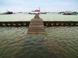
Nowhere are the effects of sea level rise more dramatic than for the two low-lying island communities, Smith and Tangier islands, in Chesapeake Bay. The two islands are only nine miles apart, but their worlds and worldviews are dramatically different.
Smith and Tangier, like the whole of the Chesapeake Bay region, are slowly sinking—or “subsiding” to use the geological term—the result of the Earth’s crust settling along this part of the coast following the end of the Ice Age. At the same time, sea level is also rising around the two islands, at least according to scientists at the Army Corps of Engineers.
The Virginia-Maryland state border runs between the two islands with Tangier on the Virginia side and Smith on the Maryland side. On the Virginia side, the leaders and residents of Tangier Island have taken the Corps’ message to heart and have been actively lobbying the engineers for funding to build a seawall along its rapidly eroding northern edge, but Smith islanders aren’t so convinced by the Corps.
With their own town government and an island high school, Tangier islanders have developed local strategies for the community’s survival. As Tangier Island resident and native Carol Moore-Pruitt told a New York Times reporter, “I don’t know anything about climate change. But if calling me a
climate-change refugee gets me a seawall, then go ahead, call me a climate-change refugee.”
On the North Carolina coast, lawmakers were concerned that scientific forecasts would damage economically powerful tourism and real estate industries.
On the Smith Island side, islanders have little patience with government at any level. The seat of government for Smith Island is not on the island itself, but on the mainland, where St. Mary’s County commissioners control basic local functions. Smith Island, with its three villages of some 280 residents—mostly watermen and their families—has never felt the need for local government. As my friend Tom Horton, an award-winning journalist who covered the Chesapeake Bay for more than 30 years, told me, Smith Island’s motto might well be, “There’s no government like no government.” The island, as Horton remarks dryly, “is as close to chaos and still on the right side of the law as you can get.”
When I landed at the main dock on Smith Island a few years ago with Horton, I marveled at the Corps’ new bulkhead, a structure that stretches along perhaps a half-mile of Smith Island’s waterfront. It is the centerpiece of a huge federal effort to minimize shoreline erosion from the relentlessly rising sea level in the bay. But the Corps is controversial among many islanders who view the agency’s offer to buy out flooded island homes as tantamount to a death sentence for the community.
How can an agency that wants to destroy the community be trusted to be objective with any kind of information? Smith islanders freely admit their island is eroding—but just don’t attach the Corps’ label of “sea level rise” to the issue.
Sandy’s Message
Further north on 32-mile-long Fire Island off New York’s Long Island, where Superstorm Sandy battered the year-round and seasonal communities in 2012, the twin punch of rising sea level with storm surges is all too real.
Sandy was a massive storm with tropical-force winds
reaching out 580 miles, with 40-foot waves and a storm surge that flooded nearly 80 percent of the island’s 4,500 homes, destroying 90 houses outright. Sandy’s damage would have been much worse if residents of Fire Island had not raised $23 million in 2009 from their own pockets to replenish a protective dune.
When the federal government proposed a $207 million plan to build a 13-foot to 15-foot-high dune along 12 miles of the island’s shoreline after the storm, there was widespread acceptance across most of the island, even though the plan would displace 40 shorefront homeowners.
“The marshes are creeping up, trees are dying, and salt water washes into everything.”
— Karen Amspacher
Suzy Goldhirsch, president of the Fire Island Association, who has family roots on the island dating back more than 100 years, said that after Sandy, “There was a serious dialogue and debate about whether to retreat or rebuild the dunes and allow our communities to remain. For us it’s not about protecting homes, it’s about protecting the culture of the island. The job of a barrier island is to take the front hit. If you’re not comfortable with that, you shouldn’t live here.”
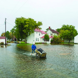
Rob Kellogg carries luggage during
flooding to The Inn of Silent Music,
a bed and breakfast that he and his
wife Linda operate in Tylerton, on
Smith Island.
(Photo: Dave Harp/Courtesy Bay
Journal)
To ‘Armor’ Or Not
Storm surges also are eating away at the sandy shores of Nantucket in Massachusetts, where a high-powered confrontation has been unfolding over the past decade about whether to “armor” the eroding ‘Sconset Bluff above one of the island’s famous beaches on its eastern shoreline. In Nantucket’s case, sea level rise is especially impacted by northeast storm surges, after which changes to the island’s shoreline become shockingly evident.
Perched above the beach on ‘Sconset Bluff are the summer homes of some wealthy Americans. The Atlantic Ocean has steadily reclaimed acres of their dunes and they were determined to do something about it.
After a long, expensive and litigious process, a local organization of private property owners on ‘Sconset Bluff received permission to install “geo-tubes”—tiered textile tubes filled with sand and layered along a 900-foot wall—to protect the toe of the bluff from being undercut by storm-driven seas.
Cormac Collier, executive director of the Nantucket Land Council, believes the geo-tubes at ‘Sconset are only a short-term fix.
“The most effective way for Nantucket to deal with erosion is retreat,” said Collier. “We are still bringing in extreme quantities of sand and it’s all paid for by landowners—the one percent of the one percent. They can throw money at the problem, but unfortunately, Nantucket is an ironic situation in that we see erosion all around us, but we are at such a loss to deal with the true problem of fossil fuel use, which people can’t wrap their heads around actually changing.”
One of the perennial problems with experts who have developed plans to engineer shorelines is that the solutions, particularly when private clients are paying the bills, often amount to a “beggar thy neighbor” approach when the structures interrupt natural processes and end up depriving others of beach sand.
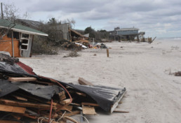
Many oceanfront homes on Fire Island, New York, were damaged or destroyed during Hurricane Sandy.
(Photo: USGS Coastal and Marine Geology Program)
Tom Chase, The Nature Conservancy’s director of conservation strategy for both Nantucket and Martha’s Vineyard, and an island native, is well aware of the disdain for expert opinions.
“My grandfather used to say, ‘Experts are nothing but mainlanders with briefcases,’” he recalled.
“Climate change is going to require redevelopment, to move out of harm’s way to safety,” Chase believes. “My thinking is we use things like a life estate-reverse mortgage. I buy it from you at today’s rate and when you go, we use it for conservation or storm takeout. If your house is impacted and we buy you out, you can redevelop in places far from serious damage.”
Blowing In The Wind
The one community that has confronted climate change by addressing its use of fossil fuels is nearby Block Island in Rhode Island. Representatives of an ocean wind development company named Deepwater Wind approached island leaders with a proposition. The wind company wanted to locate a five-turbine electricity-generating pilot project in the Atlantic Ocean, three miles off Block Island’s southern shores.
Aware of the intense local opposition the much larger Cape Wind project had encountered from many residents of Martha’s Vineyard, Nantucket, and Cape Cod, Deepwater Wind proposed routing an electric transmission cable to Block Island—the most visually affected community—to supply Block Island residents with electricity.
Kim Gaffett, a Block Island native, was the first warden of Block Island’s local government and as such, the island’s point person for negotiating with Deepwater Wind.
“The project was controversial, no question about it,” said Gaffett. “I think it was 70 percent in favor, 30 percent against, initially. Then it became 50-50.” Block Island has a year-round population of fewer than 1,000 which jumps to approximately 15,000 in the summer. There are 1,700 island homes, most of which are seasonal.
“In general,” Gaffett continued, “the seasonal homeowners were not OK with the plan because of the aesthetics.” However, electricity from Deepwater Wind is expected to
be cheaper than the cost of the island’s diesel-generated electricity. “Year-round islanders, who had been dealing with a high cost of energy, wanted it badly,” said Gaffett, adding that Deepwater’s electricity would also avoid “shipping millions of gallons of diesel to the island every year.”
Looking back at the five-year-long battle to site the wind farm, Gaffett was philosophical. She likened the appearance of the Deepwater Wind project to Block Island’s history when occasionally a valuable cargo washed up on the island’s shores.
“We could’ve thwarted it, but we didn’t, which is good. I think our biggest challenges are finding the balance between the blue-collar working class community and the affluent. I worry about those who can afford whatever they want and don’t care much about their use or what they do. In the end, I like to think the have-nots prevailed, but who knows? The locals are the ones who are proud about the project. We have a strong environmental ethic—it’s a natural extension of us, the locals.”