Whelmed in Key Largo
Flooding Threatens the Florida Keys
By Steven Harris
In the fall of 2017, Hurricane Irma’s surge advanced toward my home in Key Largo, waves curling across the lawns of properties slightly closer to Largo Sound. After the storm passed, the neighborhood was excavated from beneath branches and trees that no longer provided shade, and piles rose in front of homes, those nearer the ocean punctuated by the stark colors and straight lines of refrigerators, stoves, and furniture, ruined by inundation.
These storm events are likely to increase in frequency and power, which is unnerving because, according to Rhonda Hagg, director of sustainability and projects for Monroe County, which includes the archipelago, “the Florida Keys are the third most vulnerable community to sea level rise in the nation.”
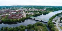
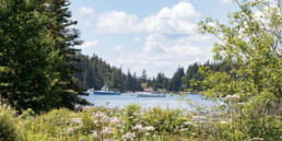
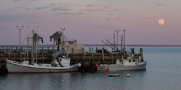
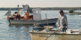
The Florida Keys, a string of islands consisting of once-submerged coral reef and oolite, stretches over a hundred miles southwest from mainland Florida, dividing the shallows of the Gulf of Mexico and Florida Bay from the Atlantic’s reefs and thrumming Gulf Stream. This nexus of habitats supports tremendous biodiversity, which in turn draws divers and fishermen from the world over.
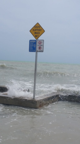
But the islands are low, and the residents have seen flooding before.
Alisson Higgins, Key West’s Sustainability Coordinator, makes it clear that they are resilient. Even though tides are as predictable as, well, the tides, strong, consistent winds push waters onto the islands, adding mystery to when and where flooding occurs. Even if an event can’t be anticipated, she says, “Once residents walk out and notice a flooding event, they change plans, adapt… Near Duvall Street, our main tourist spot, some stores keep sand bags just inside their doors,” to keep the water out. Higgins explains that Key West has been adapting its infrastructure “as the problems come. French drains helped in some areas. Miami Beach made news when it installed one-way valves so high tides didn’t flood into the streets through sewers. We did that in ’97. We still don’t have them everywhere, so 11 intersections flood during full moon high tides; during King tides, even more so. A couple neighborhoods even put in injection wells, sucking everything up, injecting it deep underground.”
The Keys face unique flooding challenges because of the islands’ geology. Hagg explained that, because the substrate is porous, “flooding comes not just from shore, but up from underground.” And, therefore, as Higgins explained, “We can’t build a wall like some European regions do. Flooding is worst during rain events in low-lying areas when it’s high tide because the rains have nowhere to go. During those events, our public works department knows when the flooding will stop: in about six hours, when the tide drops.”
Unless it doesn’t. Hagg told of a neighborhood in Key Largo where residents had seawater on their road for three weeks straight, due to a combination of heavy tides and strong winds pushing water from Florida Bay.
MAINLAND POROUS
South Florida’s mainland is porous, too, and this endangers the Keys’ water supply. Freshwater is piped 150 miles from Dade County to Key West. Much of the island chain’s water comes from a freshwater lens that sits atop denser seawater that fills the subterranean honeycomb of Florida.
“As sea levels rise, it could threaten our wellfield not just from the coast. There are even concerns about the seawater coming up from below,” Hagg said.
And Lake Okeechobee’s water, now shunted to the sea, nutrient-laden and toxic from commercial, residential, and agricultural runoff, no longer sheets down Florida through the Everglades like water down glass, recharging the aquifers. Increased demands on the aquifer cause negative pressure, drawing seawater plumes closer.
The Turkey Point nuclear plant that provides the Keys’ power uses a network of seawater channels to cool its reactors. But the cooling capacity was not sufficient during a period of high demand, and the utility sucked subterranean water to cool the reactors, moving a saltwater plume closer to the freshwater supply. The state of Florida and Miami Dade County have lawsuits against the utility, Higgins said, and Monroe County and Key West have written letters advising against expansion.
In spite of these dramatic manifestations of sea level rise, most residents don’t have to rent cars for weeks to avoid driving their own vehicles through seawater, and their taps still run fresh, so sea level rise doesn’t seem urgent. “It’s hard to notice in an average person’s day,” Higgins observed. And it is difficult to keep people informed because many residents are recent transplants whose baselines, in reference to water quality, reef health, and sea levels, began upon their arrival, long-time residents have moved on.
Visitors rarely even know about the flooding because the rainy season comes during the off-season summer and, when the King tides take place in the spring, skies are usually clear.
And tourists don’t want the spell to be broken. They dance to the region’s music which tells them to fish, drink, and forget their worries. They watch the sunset over Florida Bay as they eat fish mostly farmed and overharvested overseas. Many are spending their vacation funds, determined to believe that all is well.
But sea level rise is getting worse.
“In the last 100 years, we’ve had 9 inches of documented sea level rise, and the rate has gone up dramatically,” Hagg said. “Nuisance flooding occurred on an average of .67 times per year from 1980 to 1982. Between 2010 to 2012, it rose to 2.3 times per year. By 2060, if sea levels rise by 9 inches, flooding will occur 139 times per year. At the higher estimate of 24 inches, flooding would occur 672 times annually, so twice a day, during each high tide.”
For now, Higgins said, the pressure is felt in the wallet.
“As far as people’s daily lives, it affects your annual insurance rates more than your live-ability.” And that might be where day to day adaptation is overtaken by long-term realities. A friend of Higgins’, who has worked in real estate for years, said nobody is asking these questions. But some realtors say sea level rise will eventually diminish the value of homes on the island chain because more frequent storm events, even if they strike and saturate other parts of the country, will raise the cost of insurance.
FEMA FAIR
Not only do warmer waters feed stronger storms, sea levels determine how far up the islands storm surges advance. I was lucky during Irma because my house sits at an elevation of nine feet, in an X flood zone, which means we are just high enough that we aren’t required by mortgage companies to have flood insurance.
FEMA is reevaluating its maps and will release findings in the spring which may change flood zones. As a resident, I am grateful that FIRM (Fair Insurance Rates in Monroe County) is verifying that FEMA is using accurate data. But accurate data might be bad news.
“If the worst estimates are realized, 36 percent of our population could be displaced by 2060,” Hagg said.
Thankfully, while Margarita blenders are roaring in the resorts, people like Hagg are trying to prepare the Florida Keys for the future. Sea level rise will require “alternate forms of living and transportation,” she said. “What should the future of the Keys look like? We can’t save everything. We’re going to concentrate on what we can adapt to make sure people can stay here.”
Roads will be the top challenge because half of the county’s 300 miles of roads will be subject to sea level rise effects by the year 2060. “It will be very expensive,” she said, “maybe $10 million or more per mile depending upon how high we have to raise it.”
With just 35,000 residents in Monroe County, state and federal funds will be needed.
The most important effort of all is restoring the Keys’ habitat, not only because every job, every resident, is in some way dependent upon its unique ecosystems, not only because coral reefs cover far less than one percent of the ocean floor but support more than 25 percent of marine species, making it our duty to protect them, but also because maintaining the natural systems will help protect us. Mangroves, trees that grow finger-roots that are anchored in, and anchor, the sea bottom, act as shock absorbers that diminish the impact of storm surges. Offshore reefs knock down storm waves, making them less destructive. And these habitats are lynchpins in the tourism and fishing industries that will help fund our adaptation.
But, due to warming waters, ancient coral formations are succumbing to bleaching and disease so quickly that it is hard on the spirit. Algae blooms threaten fisheries, water quality, and wildlife, and warming waters lean hypoxic and diminish the vigor of ocean currents. With the stakes so high, the challenges so broad, it is difficult not to first be overwhelmed, then submerged in hopeless, finally turning away, hastening the flood.
Steven Harris is a freelance writer and photographer who lives in Key Largo.