
How Two French Islands Recovered, Post-Cod
How Two French Islands Recovered, Post-Cod
Saint-Pierre et Miquelon were squeezed before and during cod moratorium
story and photos By Natalie Springuel
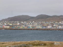
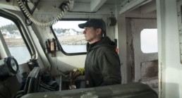
I am standing atop Le Belvédère, a commanding scenic viewpoint overlooking the town of Saint-Pierre, the population center of the French territory and archipelago known as Saint-Pierre et Miquelon. Beyond its harbor and breakwaters, over a mere 25 miles of North Atlantic seas, it is not the European foothills I see but the mountains of Newfoundland’s south coast, in Canada.
The view is stunningly beautiful. The sea is slate blue, the sky endless. Around me, low to the ground, fall colors—reds, rusty oranges, and brilliant evergreens—explode in this boreal maritime environment of stunted vegetation. The land and seascape look so much like Newfoundland, but the words of a young woman fisherman I interviewed a few days ago caution, “Don’t forget we are on a little piece of France here, on the other side of the Atlantic.”
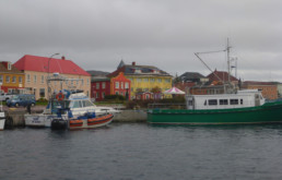
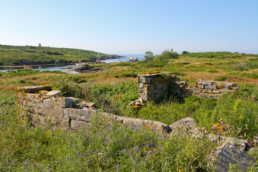
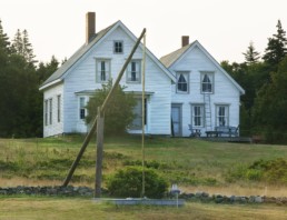
Le Belvédère de l’Anse à Pierre offers an endless view with the town of Saint-Pierre below.
I use my binoculars to investigate the scene below, the waterfront, the boats, the colorful “salines,” salt houses used to process cod up until the 1992 Canadian cod moratorium. I wonder, for the hundredth time, what was it like for these folks, French citizens on a tumble of rocks that anyone could be forgiven for thinking was part of Newfoundland, to live through the cod moratorium? Was it just as devastating as Newfoundland? Did they also lose their economy, their cultural bearings, and spill into a sea of unemployment and outmigration?
I had been studying the impact of the cod moratorium in Newfoundland for nearly 15 years and could count among my friends Newfoundlanders who had lived through those dark times and come out at the other end with hope for the future. But it had been hard, no doubt about it. This time I wanted to understand the impact of the moratorium on the 6,000 or so French citizens of Saint-Pierre et Miquelon.
The archipelago represents the last bastion of the French empire in North America. It was jostled between French and British control multiple times during the centuries of conflict for conquest of the New World. The archipelago’s strategic location made it ideally suited to serve as a base for the Grand Bank fishery. In 1815, as a result of the Treaty of Vienna, Saint-Pierre et Miquelon became, “une fois pour toute” (once and for all) a bona fide French territory, while Newfoundland remained British until it joined Canada in 1949.
Fast forward to the 1970s. France’s and Canada’s claims for territorial seas, or “exclusive economic zones” extending 200 nautical miles from shore, conflicted. Two decades later, the International Tribunal Court of Arbitration settled Saint-Pierre et Miquelon’s EEZ at a mere 24 miles around the archipelago, with the exception of a 10.5-mile-wide swath extending 200 miles south.
The ruling, a blow to French fishing rights, was compounded by the equal or worse blow imposed by the Canadian cod fishing moratorium in the waters surrounding Newfoundland, where the French government had counted on acquiring fishing quota to keep its own fleet afloat. Coastal communities in both lands witnessed the disastrous end of an era. Overnight, thousands of people found themselves out of work. Both economies came to a grinding halt, uniting the people by their shared crisis.
Today, it is apparent that Canada and France picked up the pieces in very different ways, producing neighboring societies that are strikingly distinct.
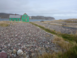
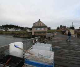
L’Île aux Marins, a 10 minute ferry ride from Saint-Pierre, was once home to hundreds of cod fishing families who dried their catch on gravel beds maintained mostly by children.
In Newfoundland, the government response included offering payments and retraining programs for those put out of work, along with regional community development strategies aimed at fostering business innovation. Well-meaning as these programs were, outmigration was massive and many Newfoundland outports lost up to half of their population to the “tar sands” of Alberta and other places with the promise of work.
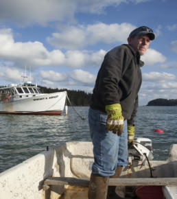
Paradoxically, Saint-Pierre et Miquelon’s population remained remarkably stable with employment shifting to other sectors. During my fall 2019 visit, homes appeared lived in, lights were on, people had jobs, retirement pensions, medical coverage, and an apparent lack of social need. I was not seeing neighborhoods losing residents to outmigration. On the contrary, people were coming here to work! I met people from “La Metro” (continental France) working in bakeries, hotels, restaurants, government posts, and even as deckhands in the fishery, like the young woman who had come for a job on a groundfish trawler.

Tourism, focused on the archipelago’s rich fisheries heritage and maritime environment, is an important strategy in the French government’s plan for Saint-Pierre et Miquelon’s future. This image was shot on L’Île aux Marins, and the steel map represents that island.
How could it be that Saint-Pierre et Miquelon had jobs aplenty while Newfoundland outports had so few? France’s response to the fisheries crisis, it turns out, was to activate government support on a scale that was simply inconceivable in North American countries.
By some accounts, government now provides for more than half the archipelago’s economy in the form of administrative jobs with local government, and federal subsidies for various enterprises such as the hospital and the electric company. Many of the people I encountered were in positions supported in some way by federal and territorial government: airport and port crews, construction workers, radio personalities. Americans, my new French friends scoffed, will dismiss such widespread government support as socialism; but isn’t it, as they insisted, just the French government taking care of its people?
I could not help but think that this society seems to have weathered a storm that Newfoundland is still untangling. But it was not that simple. Several business owners worried that people have become complacent, assuming their kids will grow up, get a job with “l’administration,” and live the same standard of living they enjoyed. The comparatively high level of administrative backing seems to have unleashed an era of dependence. Some Saint-Pierrais I met were concerned that government investment is never guaranteed. The whims of European politics could change everything.
Not all view dependence on La Metro as a sustainable path going forward. Even the territory’s government officials recently announced on La Première, the local branch of national television, the need for economic diversification, and tout tourism as one solution. Indeed, the archipelago’s natural and cultural assets truly are unparalleled, and cruise ship visits are on the rise.
But one hotel and restaurant owner I spoke with struggled to find young employees to fill the jobs required in the service sector. With so many comfortable in their government jobs, the labor shortage is acute. This explains, in part, why even bakery workers, garage door installers, and, most ironic given the archipelago’s maritime history, fishing boat crew are imported.
~
One rare entrepreneur I met observed that the initiative needed to diversify the economy away from the French umbilical cord is extremely uncommon. Most people just don’t want to take the risk of venturing into the private sector. But what does that do for the businesses that are necessary to keep society functioning? What does that do for private investment? What does that do for entrepreneurialism and innovation?
Back in 2008, when I lived in Newfoundland for six months, Newfoundlanders bemoaned their government’s reliance on social enterprise for pulling society back up. Newfoundlanders, having lived for centuries dependent on cod, had never developed the business capital, the skills, or even the mental disposition for entrepreneurialism to be a real option, they said.
But now, 27 years post-moratorium, as Newfoundland slowly emerges from economic and social collapse, a sense of entrepreneurialism is taking root. Microbreweries, award-winning museums, world-class hotels, a growing foodie scene, all are examples of the solutions Newfoundlanders are putting into place to breathe life back into their communities.
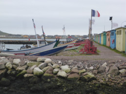
“Les Salines” or salt houses, where dory fishermen processed their catch and maintained their boats.
Often, it is the now-adult kids of those put out of work by the cod collapse who are picking up the pieces. It has not been without cost: thousands lost to outmigration and the shattering of a centuries old identity. Challenges remain for sure, but Newfoundland in 2019 feels, as they say, “on the go.”
~
Back up on Le Belvédère overlooking the town, I take a deep breath as I scan Newfoundland in the distance and notice the small cruise ship steaming out of the Saint Pierre harbor. It is my last day on the island. I turn, facing southwest, and look across the sea. My thoughts turn to Maine. I can’t help but wonder: how would Maine fare if the lobster fishery crashed? Would the aftermath be as powerful as the cod crisis has been on the colorful town beneath my feet? Would it be as catastrophic as it was on the Newfoundland outports below those mountainous silhouettes across the sea? It is hard not to draw cautionary lessons.
How would we react if lobster really declined? Would we choose to take a more Canadian approach and attempt to boost regional development while counting on market forces to usher in new industries, but risk a declining population? Or would we choose the French approach of assuaging economic crisis with an outpouring of government jobs and subsidies, while risking a dependent population?
I will admit that in my comparison of the two, I found France’s commitment to the permanence of the archipelago’s population, whatever investment that might take, a hopeful counterpart to Newfoundland’s outmigration crisis, especially at first. But the realities on the ground, in both cases, led me to see that both approaches have some promise and some pitfalls for regions like Maine, where uncertainty about our future fisheries looms over any planning for a sustainable future for our coastal communities.
Maine’s coastal economy, except perhaps Washington County’s, has the advantage of greater diversity to begin with. Public-private partnerships are part of how we function. I think of examples like federal grants to our burgeoning aquaculture sector, non-profit loans to small or women-owned businesses, and regional partnerships for tourism development.
One thing is certain though: if Maine ever experiences a dramatic downturn in the lobster economy, Maine’s coastal communities will undoubtedly change. Unanticipated change can come fast and furious, leading to crisis and crisis response that can have an impact on the trajectory of entire societies for decades hence. But change can also usher in new ideas, creative adaptations, and potentially better ways of doing things. It is how we respond that will make all the difference.
Natalie Springuel has been a marine extension associate with the University of Maine Sea Grant, based at College of the Atlantic, for 20 years. She is grateful for research and travel support from College of the Atlantic, Island Institute, Canadian-American Center at the University of Maine, and the University of Maine Sea Grant College Program.
Islands Were First Footholds for European Settlers
Islands Were First Footholds for European Settlers
Safety and ease of transportation were attractive, historians say
By Jacqueline Weaver
At one time, 300 of Maine’s nearly 5,000 islands had year-round communities. Today that number has dwindled to 15 islands that are occupied through all four seasons.
“When Europeans got to the coast of Maine, they set themselves up on islands first, because they were uninhabited and they were, or felt, safer,” said historian Lincoln Paine, author of Down East: An Illustrated History of Maritime Maine (2000). “Only after they had the lie of the land, and of the various Wabanaki people who lived there, did they start moving onto the mainland.”
Paine said there were an estimated 400 European fishing vessels active on the Maine coast in the 1620s. Bill Caldwell, author of Islands of Maine (1981), said islands off the coast of New England, particularly Maine, were attractive because of the fertile fishing grounds there and around the entire Gulf of Maine.
“The first roots of the United States are not in the soil of the mainland, but in the fishing grounds off the coast of Maine,” Caldwell wrote. “Fishermen began this nation in rough, temporary settlements on the Maine islands.”
One of the earliest settlements by mariners from Europe was Damariscove Island off the coast of Boothbay Harbor. The two-mile long, quarter-mile wide island housed families who farmed and fished from the 1600s into the 1930s. Caldwell wrote that for centuries, fishing, boatbuilding, and lumbering drove the Maine economy, spreading down the coast from Newfoundland to the Isle of Shoals off Kittery.
The fish provided a steady food supply and a product to sell, helping to establish America’s earliest trading centers, Caldwell explained.
“The first roots of the United States are not in the soil of the mainland, but in the fishing grounds off the coast of Maine.”
—Bill Caldwell
According to the late historian Samuel Eliot Morrison in The Story of Mount Desert Island (1960), the first mariner to arrive on Mount Desert Island was Estevan Gomes, a Portuguese who was sent to find a comparable and northern version of the Panama Canal to establish a link to the Pacific. What he found was Mount Desert Island, or what he called “River of Mountains,” as he navigated along Somes Sound.
When Samuel de Champlain arrived in 1604, he called Mount Desert the “Isle Of Bare Mountains,” or “l’Isle des Monts-deserts.”
“The economy of the island settlers was based on forest and sea,” Morrison wrote. “By 1870, almost the entire first growth of timber was cut off, if not burned down, to make lumber, ship timber, and cordwood.”
A visitor in 1792 could have seen ships in Frenchman Bay sailing for London, Santo Domingo, and Boston, with cargoes of plank, timber, shooks (wood cut for barrels), bark, and cordwood.
Philip Conkling, author of Islands in Time, wrote that the mostly French and English settlers were attracted to the islands for their proximity to fishing grounds and the islands’ defensive advantages. Granite also was a part of several islands’ economic engines. At the height of the granite era in the 1880s and 1890s, Vinallhaven supported a dozen large quarries, Conkling wrote.
The remains of centuries-old settlements
on Damariscove Island.
“At one time there were 33 major island quarries among Maine islands stretching from Friendship to Jonesport,” he wrote. The granite was used for breakwaters, paving blocks, libraries, monuments and memorials, and cobblestones. The granite era ended with the introduction of cement, since the material was cheaper and easier to handle, Conkling notes.
Also adding to the industry’s demise, he noted, were an end to lucrative government contracts, construction of railroads on the mainland, and labor unrest.
But the true beginning of the end for Maine’s islands was the invention of the internal combustion engine. The car ended the heyday of the steamboat, which carried passengers, and the schooner and other cargo ladened vessels.
Paine said that prior to development of the car and roads, boats were the easiest way to move along the coast of Maine, easily connecting to islands, peninsulas, and around the entire Gulf of Maine. A boat with one to two people could handle the equivalent of a truckload of cargo and a busload of people. But the advent of the car gave people an unprecedented mobility.
“If your primary means of transportation was boats, you didn’t have much incentive or ability to go inland ever if you went to the mainland,” said Paine. “But with cars, you could go to Rockland or Portland and hit the open road.”
The decline of the boat culture and the rise of the car culture is evident in the demise of the steamboat lines in the 1930s. The night boats between Boston and Bangor stopped running only four years after the opening of the Waldo-Hancock Bridge in 1931.
“Cars connected the archipelagoes of cities and towns around the country the same way that boats had connected the archipelago of islands and towns on the coast of Maine,” Paine said.
The transportation revolution had a major impact on peninsula towns as well because the towns were tied to the islands as much as, or even more than, to other mainland towns.
“So you can imagine Route 1 as nipping the peninsulas off one by one as it heads down the coast,” Paine said.
Jacqueline Weaver lives in Wonsqueak Harbor on the Schoodic Peninsula. She has reported and written for UPI, Reuters, the New York Times and, most recently, the Ellsworth American.
Maine Triumphs Through Coastal Law
Maine Triumphs Through Coastal Law
Winning enough votes meant reworking federal rules on shipping
By Stephanie Bouchard
In September 1816, William King, a politician and businessman in the District of Maine (and at one time, the wealthiest ship owner in the region), was certain that finally, after 30 years of trying to leave Massachusetts, Maine would succeed in getting the votes to become its own state. Voters of the district’s coastal communities would soon cause him to trim his sails, but in that moment of pre-disappointment, he had good reason for optimism.
The outrage among Maine residents toward Boston’s failure to protect the district during the War of 1812 had not cooled, and the numbers from the last vote for independence—held just five months earlier—showed that the votes were there, so King and his colleagues with good reason thought a win was in the bag.
When the vote results were tallied, the separationists did have more votes than those opposed. They didn’t, however, have a 55.5 percent majority, a stipulation required by the state government in Boston for the separation to move forward.

Frustrated that voters in the coastal communities still overwhelmingly voted against leaving Massachusetts, and that they’d be losing statehood over a technicality imposed by Boston, the separationists were desperate. When, four weeks after the district-wide vote was held, delegates of Maine communities met to review the returns and assess next steps, shenanigans ensued.
In an effort to win separation, there were claims that returns from some of the towns were lost; the legality of some votes was questioned (they were “incorrectly” or “illegally” returned or the question on the ballot was not appropriately worded or unqualified voters had voted); debate on what the word “majority” meant concluded in a “truthiness” definition that allowed for some fuzzy math, and voila, the 55.5 percent majority was achieved!
Anti-separationists were apoplectic. The fallout was, as we say in Maine, wicked bad. Massachusetts didn’t buy it, and those who perpetrated the scheme were castigated in the press. After such obvious foul play, the optics were just too bad for Boston leaders to allow separation.
King and his cohorts laid low immediately following the fuzzy math debacle, but he was as determined as ever to bring about Maine’s statehood.
In that September 1816 election, even though there were more votes for separation than not, once again, the biggest number of opponents came from coastal communities where the Coasting Law reigned. If Maine was ever going to become a state, King knew, he had to get more votes from those coastal communities, and there was only one way to crack that nut. The Coasting Law had to go.
~
The Coasting Law had been a problem for separationists since 1789, when Congress passed an “Act for Registering and Clearing Vessels, Regulating the Coasting Trade, and for Other Purposes,” otherwise known by the more succinct Coasting Law. This law required vessels sailing along the Atlantic seaboard to stop at a custom house in each state along the way and pay a fee (both the trip out and the return). Vessels only had to stop and pay the duty in states that didn’t border their originating location.
The only state Maine shares a border with is New Hampshire. Because the district was part of Massachusetts, however, Maine ships didn’t have to stop and pay a fee until reaching New Jersey. This was a big deal for Maine’s coastal communities, said Pulitzer Prize-winning historian (and Maine native) Alan Taylor, author of Liberty Men and Great Proprietors: The Revolutionary Settlement on the Maine Frontier 1760-1820.
Having to pay those fees would be a “significant bite” into anyone’s profit margins, he noted, but especially so for merchants shipping low-value commodities like cord wood—which Maine merchants were exporting a lot of at the time. Plus, it would have been a huge time-suck to make all those stops coming and going. Just like today, the faster something ships, the better.
While the population of Maine’s interior towns steadily grew after the Revolution, the folks on the coast were the ones with the juice, Taylor said. Coastal communities had the highest populations, the most political clout, were most dependent on coastal trade, and had close ties with Massachusetts.
With the Coasting Law in place, folks who lived in Maine’s coastal communities (and those nearby who did a lot of business with them) had zero incentive to jeopardize ties with Massachusetts, he said. The Coasting Law then became the roadblock that held the separationists back. After the 1816 brouhaha settled down, William King, the wealthiest ship owner in the district, set his sights on the federal law.

Gilbert Stuart’s 1806 portrait of William King.
King wasn’t known as the Sultan of Bath for nothing. He had steadily gained prominence in the District of Maine and in Boston. Born and raised in Maine, he worked his way from laborer in a saw mill to owner of one. He went on to building and owning ships, owning a store, investing in substantial real estate holdings, opening the first cotton mill in Maine, and founding the first bank in Bath, a shipbuilding city on Maine’s Midcoast where he settled.
Voters in the coastal communities still overwhelmingly voted against leaving Massachusetts…
He also served in Massachusetts’ House of Representatives and Senate and had connections in high places, namely, his older half-brother, Rufus King, a lawyer in New York who was a delegate to the Continental Congress and the Philadelphia Convention, a signer of the U.S. Constitution, and a U.S. senator (he later also was a presidential nominee).
Late in October 1818, King made the long journey from Maine to Washington, D.C. He met with his brother, Rufus, for advice and support, and with William Crawford, who, as treasury secretary, oversaw the laws regulating the coasting trade. King hoped to sway Crawford into agreeing to a revision of the Coasting Law.
Bucksport Village on the Penobscot River in 1859. Painting by James Emery.
King got lucky. Crawford agreed to support a revision. King returned home and started planning for what he hoped would be the final effort to become a state.
In the early spring of 1819, the revision to the Coasting Law passed in Congress. The new law got rid of the state-by-state stops and fees, and instead designated the Atlantic and Gulf coasts into two districts, with the upshot being that Maine merchants could sail the entire Atlantic coast to Florida without stopping to pay duties.
With the coast (literally) cleared, the floodgates opened. A district-wide vote on separation was scheduled for July 26, 1819. It was the largest turnout ever for a separation vote. While voters in coastal communities still voted more against separation than for it, said Liam Riordan, a history professor at the University of Maine in Orono, there were more yesses than in previous votes—enough to make the difference. The vote for separation passed by a margin of 10,000 votes. At last!
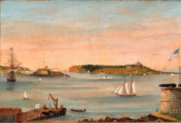
Portland harbor circa 1853. Artist unknown.
Being admitted to the Union as a state should have been—and was expected to be—easy. But to the shock and consternation of all Mainers, the path to statehood became entangled in what has been called the most explosive controversy of its time: an effort to stop the growth of slavery.
In the course of a heart-pounding two months, Maine was embroiled in the political battle that resulted in the Missouri Compromise, which created a boundary for the extension of slavery into new territories, set the stage for the Civil War, and pitted members of the Maine delegation to Congress against each other.
It was not the way Mainers wanted to enter the Union, but in March of 1820, the 35-year struggle to become a state was finally accomplished, with Maine becoming the 23rd state of the fledgling United States of America.
Stephanie Bouchard is a freelance writer and editor based on the Midcoast. Find her at www.stephaniebouchard.net.

Cliff Island — A Labor of Love for Cheryl Crowley
Cliff Island — A Labor of Love for Cheryl Crowley
Quietly, but effectively, she works to keep the Casco Bay island vital
By Tom Groening
Photos by Lorinda Valls
Cheryl Crowley offers a vivid metaphor for the challenges and rewards of working to support a small island community.
“It’s like painting a house,” she says. “I hate all the scraping. But then, after the final coat is applied, it’s Ahhhh!”
Crowley has been scraping away, reimagining, and applying a fresh coat to her beloved Cliff Island for years. Though she had to have her arm twisted to consent to an interview about her volunteer work, she is, in fact, one of a small number of folks on this island of about 50 year-round residents plugging away at keeping it vital.
The journey that led Crowley, 56, to Cliff Island—which lies at the southeast edge of the Casco Bay archipelago, the last stop on the outbound ferry run—is as angular as its shore. Her family has visited the island since 1916, but she grew up in Trumbull, Connecticut, where her father was a school teacher.
While in high school, Crowley worked as a nanny for a family on the island, and, that same summer, met David, who today is her husband.
She attended and graduated from the University of Maine at Farmington. Later, following in her father’s footsteps, she became a teacher, working in special education in the Gray-New Gloucester system in southern Maine. Later, she ran a group home for disabled adults in central Maine.
After her first marriage ended, she moved to the island in 1996, while her grandparents were still living there, and never left. She reconnected with high school friend David, and married and had a family. His family had a cottage on nearby Stave Island.
“He migrated south to Cliff,” she jokes. The couple have three girls, one still attending Casco Bay High School in Portland. And it was being the parent of school-aged children that led to her volunteer work, a natural progression for many, she observes.
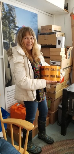
Crowley holds a roll of fiber optic cable, which is used to upgrade internet speed.
“Being on the island, and being available, I started getting busy,” she recalls.
Crowley began substitute teaching, then lending a hand in administrative work, like helping hire a teacher for the island’s one-room school. Even though her daughters no longer attend, and the school has just two students, she remains actively involved.
“I can’t let it go,” she says with a smile.
Early in 2018, the Portland school system considered closing some island schools, which drew her into fighting such a move, and a commission formed to study the matter.
“I’m on that, too.”
Crowley also is her island’s representative to the Maine Islands Coalition, a group that gathers to discuss island issues.
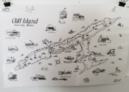
Sustaining Island Life
Since Cliff Island is part of the city of Portland, it’s challenging to create island-based organizations for activities typically operated by a municipality, Crowley explains. To address the lack of summertime programs, islanders formed the Cliff Island Corporation for Athletics, Conservation, and Education (known on-island as “ACE”). Among the offerings it made possible was live music.
“It’s really awesome,” Crowley said, as residents and summer folks gather at the pier for the performances.
Another island-based entity, Cliff Island Association, operates the community hall. Last summer, residents supported a plan to expand the hall to house the hardware for high-speed internet.
Another big step was taken when Crowley and islanders Roger Berle, Bob Howard, and Eric Anderson formed Sustainable Cliff Island.
“We started this way back when—12, 13 years ago,” she remembers. “It was about housing,” trying to create more affordable options, a common concern on Maine’s islands. But the effort was set aside when the housing bubble burst.
Five or six years ago, the group became active again, and seized on an opportunity that was presented when a waterfront parcel of land that had included a pier, fuel depot, store, and house had been seized by the city of Portland when its owner failed to pay property taxes. The city put the property out to public bid, and Sustainable Cliff Island secured it for $10,000.
The house on the parcel could only be rented or sold as affordable housing for the next 20 years and the fuel depot must to be maintained as such for 20 years, were the conditions attached by the city.
“It’s all about sustaining a year-round community,” Crowley explained.
The elements that must be supported for such vitality include affordable housing and a school, along with what had been at the now-secured property—store, fuel depot, and access to the water. To that list she adds jobs and access to broadband internet.
Sustainable Cliff Island is still working on plans for the waterfront parcel. The old fuel tanks have been removed, and the wharf is being rebuilt. The store could be revived in some form, she said, and the small house might serve as a residence for an island teacher.
“We need to gut the house,” she said. “It needs a lot of work.”
The property also might help serve the island as the base for a health clinic. Earlier on in her island volunteer work, Crowley dove into health care–inspired by her mother, a nurse–and persuaded Portland city officials to hold EMT classes on the island. She and husband David now are two of the island’s three EMTs. Crowley and Peggy Akers, a summer resident, have worked to expand medical services.
“We’ve created an informal health center,” she said, clarifying that the “center” looks like a Rubbermaid bin
with supplies.
Focusing on health is a passion for Crowley.
“I love it,” she says. “It’s one of those things that doesn’t divide a community.”
Working on offering home care for aging island residents is another project on the agenda for Crowley.
Island life agrees with her.
“I love the nature of it—being in the elements, skiing in the middle of a snowstorm,” she says, along with the deeper, multi-generational relationships that form. “I see that in my girls. They’re so accepting.”
Roger Berle, a fellow Cliff Islander, has worked closely with Crowley on a number of projects. “I’m a huge fan,” he said, adding that he’s known her since she was a child.
“She is smart. She is patiently thoughtful. She’s got her eyes wide open and she’s pretty quick to understand where people are coming from,” Berle said, adding that Crowley has one foot in the year-round community and one foot in the summer community, making her effective.
“She is quietly persistent, a quiet but effective leader,” he continued, with “a wonderful personality” that gives her “a way with people.”
On the day we talked, Crowley was in Portland to attend a meeting of the Casco Bay Lines board of directors, hoping to lay the groundwork for designating a private space in its terminal for cancer patients while they wait for their ferry
back home.
And in explaining her plans, she disclosed something about her approach to community work. Rather than demand change, she said her goal for the meeting was to gently introduce the idea.
“I like problem-solving. I like to collaborate,” she says, when asked what drives her volunteer work.
Tom Groening is editor of Island Journal.

Keeping the Home Fires… Out
Keeping the Home Fires… Out
Islesford’s Katelyn Damon a driving force for island fire department
By Casey Engelman
Photos by Jesse Groening
The stormy November morning crossing to Islesford (Little Cranberry Island) was rough, even by islander standards. And later, when the weather knocked out power on the island, the vital role Katelyn Damon plays in the community and surrounding islands became clear.
“She’s pretty much the reason we have a fire department,” says Paul Hewes of Great Cranberry, one of the Beal & Bunker ferry crew members. “She’s really tied it together.”
Damon, 31, a native of nearby Lamoine, is the island’s public safety guru. She attended Mount Desert High School, and has been living and working on the island since 2010. An AmeriCorps position first called Damon to the island, after which she remained and was hired part-time by the fire department.
On the dock that morning, Damon bids goodbye to each of a half-dozen well-seasoned fishermen before heading to her home base most days—the Islesford firehouse.
“I had absolutely no background in public safety. No background in volunteer management. No background in anything,” she says.
And still, she was able to piece it together. Damon says it was her determination to fulfill the job requirements with dignity and her sense of attachment to the island that encouraged her to make it work.
“I quit college, actually, to live out here, because it didn’t seem like a good use of money to try and keep going to college when I just wanted to be here. I just love this place. And then the town offered up that position and two people applied—myself and another islander. And they chose me and so from there I had to figure it out.”
Her desk at the firehouse is a testament to how much Damon has going on each day. A white board covered in meticulously categorized lists is the centerpiece—checked boxes account for everything from budgets to community training, hose and fit tests, OSHA and HAZMAT regulations. On the desk, to-do lists and “to-file” folders share space with clipboards of monthly safety and health audit checklists and notebooks, presumably filled with more lists and notes.
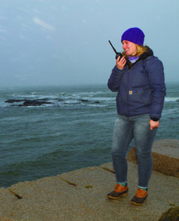
Damon communicates with other emergency responders during the outage.
Prioritizing organization seems to have helped Damon make some headway on longtime goals for the fire department. Since 2010, their focus has been on achieving an Insurance Service Organization (ISO) rating of 9. This rating is an assessment of a fire department based on risk, or in layman’s terms, how much water it can deliver, and how fast and how long it can sustain delivery. Achieving this rating reflects well on the department, and means financial savings for islanders.
“We had to show we were completing trainings on a regular basis, were servicing trucks, and were having these tests,” she said.
“So we had to show that history in those things before we could even apply for ISO class 9. They didn’t even want to hear from us until we could show that we were continually doing those things.”
And though getting this box checked meant filling out a lot of paperwork on Damon’s part, along with waiting for a 2,500-gallon cistern to be installed in the town field, it also meant benefits for the island community. The department’s goal was finally reached in June of 2018. As a result, Damon says islanders have seen decreases in home insurance premiums of between $500 and $2,000.
She continues to speak of the benefits to the island when the building goes dark—the power may be off, but Damon’s emergency response mode is kicking in full throttle.
“We need to head down to the dock,” she says, packing her bag and putting on her coat with cool urgency.
The dock has the best cell reception, and Damon corresponds with the utility company on behalf of the town in instances like this. In cases when the timeliness of aid is often based on the number of affected individuals, efficiency in communication is critical.
After calling the utility company, she posts on Facebook about the information she’s gleaned—a downed tree on Great Cranberry means their power had to be cut for linemen to make the repair safely. They’ll be out on the
11 a.m. mail boat. An islander walks to the truck and starts chatting with Damon about the outage; she briefs him.
“Power went out, but the generator’s on. It’s all good,” he replies, prepared for storms of this nature and their effect on the island.
He walks back to the lobster co-op pump, where he fills his tank with gas to keep his generator going, and Damon goes back to virtually communicating with the islanders and the fire chief. The island is small, and Damon recognizes the need for intentionality and community when it comes to dealing with emergencies.
“We’re it. There’s no mutual aid. There’s no other truck from another town that’s going to show up and bring equipment and be able to help us truck water or add additional firefighters,” she says.
Though a small community, it is a well-oiled machine when it comes to coping under pressure. Damon has an on-call fire corps comprised of men who are prone to be at sea during fishing season, and so has compiled a secondary land-based list of firemen for times of need. And despite her age, she can still command the group with grace.
“They don’t give me any guff. I’ve been lobstering and worked on the boats, and done the fire stuff, EMS.
So they listen. I also will yell if they don’t,” she says. “I’m younger, I guess, but we’re like a big family. So everybody pitches in and gets along.”
On Islesford, it seems some of the energy to sustain and revitalize the community and infrastructure has been initiated by younger folk like Damon. Malcolm Fernald initiated connecting the island to broadband, and the company representative, Nate, served as a volunteer EMT while on the island. Richards Howland, the current fire chief, is young by island standards. A new firefighter on Little Cranberry is a recent transplant from New York with more experience than Damon had seen in a while, bolstering the presence of capable workers creating a life on the island.
This camaraderie came in especially handy one day in October 2018. A local man went missing and the Hancock County Sheriff’s Department, Maine Warden Service, Damon, and Fire Chief Howland stayed up most of the night planning and devising plot maps for grid searches. Damon says it was one of the scariest things she has had to do professionally, but couldn’t have accomplished it without the people of Islesford.
“It was tough, but the whole community came together to help find him. We had 60 people waiting outside the town office for instructions on what to do. The town offices, they set up tables, it was our hub for volunteers waiting to search. And people that couldn’t search made food and made coffee and tried to make everybody comfortable. The store on Great Cranberry sent over plates and drinks and water and all kinds of things. Everybody was right there.”
Sadly, the search ended with bad news, but the scene Damon described speaks of a functioning community, in which volunteers and professionals blend their efforts. She’s earned accolades for her work, and holds the titles of the island’s public safety coordinator, constable, emergency manager, rescue service chief, and firefighter. And mom. Damon can send her five-year-old son to walk down the street to a friend’s house with an eased mind. She can help neighbors unload their month’s supply of groceries from the mail boat in the winter, and take heart in knowing they will turn around and do the same for her.
“There’s no hustle and bustle about things, it’s just very relaxed and calm for the most part. Until the radio goes off and then it’s not. But that’s OK, it adds a little adventure to the slowness. The scenery, the views, the beach. Picking up seaglass, and walking the dogs off leash and not having to worry about a whole lot.”
Later that afternoon, the waves have calmed and the mainland is in sight. Several residents of Little Cranberry are on the return trip. Paul Hewes and the other crew member chat with them about that morning’s weather and the rumored outage on the islands. All present are in the loop on what’s happened, and how it will be mitigated, thanks to the quick and efficient communication between Damon and her fellow islanders. It brings comfort to know that in a moment that could have meant sustained darkness, she is there to spread the light.
Casey Engelman is a recent transplant to the Midcoast. She attended Indiana University, where she studied Journalism and Food Anthropology, and often employs both disciplines in discovering the treasures of everyday life to create her stories. She works full-time as a baker.
Kristan Porter Remains Grounded as Fisheries Shift
Kristan Porter Remains Grounded as Fisheries Shift
From his perch Downeast, the new president of the Maine Lobstermen’s Association sees challenges, opportunities.
By Laurie Schreiber
Photos by Leslie Bowman
Anyone who’s been to any confab in the various Maine fisheries over the past couple of decades will likely recognize Kristan Porter—a steadfast presence and an articulate voice in the thorny world of management and policy.
That’s true now more than ever, since he took over as president of the Maine Lobstermen’s Association board of directors in the spring of 2018. He succeeded David Cousens, who was president of the MLA for 27 years.
“I’m not on the 27-year plan,” Porter says with a laugh. “But we’ve got some really good young people on the board. We’ve just got to make sure, when we go to the legislature and go to these council meetings, that they tag along and learn the ropes and are ready to step up.”
Porter is typically on the go. Usually, he’s on the water hauling lobster traps or dragging for scallops, or performing maintenance on his two boats and gear, or representing the industry at countless industry and management meetings. The meetings take considerable dedication from the travel standpoint alone.
“If you’re in Portland, you can zip to a council meeting in Massachusetts fairly quick,” he says. “But it’s six, seven hours for me. I was in Providence, Rhode Island, this Tuesday for a meeting,” he said. “So, basically, Monday was a travel day. I got home Tuesday night at 9 o’clock and was out fishing Wednesday morning.”
An easygoing person, Porter comes across as quietly thoughtful. On a Sunday afternoon, he was taking a rare moment away from work, ensconced in the beautiful 1910 home he shares with his wife Brenda and their son Brandon (two daughters, Whitney and Ashley, are grown). The house, on the shore in the Washington County town of Cutler, has picture windows overlooking a working harbor that includes his Wesmac 42 lobsterboat named after his daughters and his 40-foot Novi scallop dragger, named for his son.
Growing up in Cutler, he has deep affection for his small community, love for his work, and a willingness to speak for its cause. He understands the importance of building relationships and collaborations across various interests.
“It takes a lot, sometimes, to be able to bite your tongue,” he says. “You’ve got to be able to lay out the facts and be level-headed. But you have to do that in a respectful way. The people who do well in fisheries management—or in anything, probably—are those who can go to a hearing or a meeting and fight for their side but, after the meeting, can go have a beer with somebody and be cordial. Maine is not a very big state. You can’t burn your bridges.”
Cutler hasn’t changed much since he was a kid, says Porter, who is in his late 40s. The fishing boats are larger and more expensive than they used to be. But basically, the community’s families and rural feel have endured. With a population of just over 500, Cutler is a place where everyone knows each other.
“If something happens, everybody’s there to help,” Porter says. “Everyone looks out for each other. “
Porter’s family goes back to the town’s settlement in the 1700s. Various members of previous generations fished—lobstering, tub-trawling, hand-lining, stop-seining. Fishing skipped a generation with Porter’s father, a carpenter who built many of the homes here.
Raised half a mile up the road from his home today, Porter fished with older cousins in summers and on weekends. He loved it. Still, heading to the University of Southern Maine, he thought he’d become an industrial arts teacher—until he finally got into a classroom and discovered he didn’t like teaching.
It was the early 1990s, when groundfish stocks were tanking and regulations were tightening around the lobster fishery. Correctly predicting it would eventually become more difficult to get a license in various fisheries, Porter realized that if he wanted to fish, it was time to jump in. So he returned home, bought a boat (putting up his ’68 Firebird as collateral), and started in scallops and mahogany quahogs. Maine’s sea urchin fishery was on the rise, thanks to a Japanese market for urchin roe, so Porter fished for that, too, and got into lobstering.
“Once I got rolling, I just kept building up,” he says.
Today, although he hasn’t fished for mahogany quahogs for a few years, he maintains a routine of fishing for lobster through the summer and switching to the state’s scallop fishery when that opens in early December. Come spring, he and other Maine fishermen motor to Gloucester, Mass., to drag for scallops in federal waters.
Porter got into fishery politics early on. He was on the Maine Fishermen’s Forum board of directors for 22 years, serving as president for ten. (He gave that up once elected as MLA president.)
The forum is one of the best things for the fisheries, he says. Founded in 1975, it features three days of education and communication for fishermen and fishery stakeholders. Mainly it’s a great opportunity for everyone to get together.
“A lot of stuff has been figured out in those halls, or down at the restaurant,” he says.
He was a founder and president of the now-defunct Downeast Draggers Association, and has served on the Sea Urchin Zone Council, Sea Urchin Advisory Council, Maine Sea Grant Policy Advisory Committee, Department of Marine Resources Advisory Council, Maine Fishing Industry Development Center, Atlantic States Marine Fisheries Commission’s herring advisory panel, New England Fishery Management Council’s scallop advisory panel, and a federally convened, multi-stakeholder group called Atlantic Large Whale Take Reduction Team. (He’s also been a Cutler selectman.)
Changes were happening in state and federal fisheries, as the industry and regulators began seeing greater need to protect fishing resources—like groundfish, urchins, scallops, and shrimp—from depletion. Then, too, there was growing concern about endangered North Atlantic right whales and other large whales whose lives are at risk when tangled in fixed fishing gear like lobster trap lines.
Numerous measures have been implemented over the years to address these concerns. Maine’s scallop resource is an example of the success of measures like conservation closures; the state recently announced the first new entrants into the scallop fishery since 2009.
“So far, so good,” says Porter. “It’s on the right track. There are still areas that need some improvement, but a lot of areas have come back.”
Lobster Boom
Although many fisheries are in flux, the lobster resource has boomed: Landings are more than triple what they were in the early 1990s, and the value shot from $61 million in 1990 to $484 million in 2018. But today, the lobster fishery faces two near-existential issues: “Whales and bait,” says Porter. “Anything else is noise.”
An increase of North Atlantic right whale entanglements in fixed fishing gear in 2017 and 2018 resulted in deaths and injury in the endangered population. Maine’s lobster industry has been proactive in implementing measures to reduce entanglements, and none of the gear in the incidents was identified as coming from Maine. Still, the incidents triggered a provision in the U.S. Endangered Species Act that reinstates the consideration of human impacts on the animal. Called a “biological opinion,” it could result in new federal restrictions on the fishery.
The Atlantic Large Whale Take Reduction Team has been studying measures that include new methods to reduce the breaking strength of vertical end lines to 1,700 pounds, and ropeless fishing, which would implement acoustic technology to trigger deployment of a buoyancy device, lifting the trap to the surface.
Porter has spent years with other stakeholders developing gear modifications to reduce entanglement risk. Initiatives today include an industry, state, and academic collaboration on the question of the breaking strength of rope.
“There’s this magic number of 1,700 pounds of breaking strength,” Porter says. “If we find that Maine is already at the goal, does that mean they move the goal posts?”
Ropeless fishing technology is nowhere near feasible,
he says.
“I don’t think people comprehend how dangerous and
complicated it is,” he says. “It sounds easy—just go out and throw your gear over, and then when you want it, you pop it back up. But how do I know where your gear is and how do you know where mine is? How does somebody with the mobile gear fleet know where anybody’s gear is? If we can’t buy this stuff off the shelf, how are we going to do this?”
The bait question revolves around Atlantic herring, lobster fishermen’s favored bait.
“I don’t think people yet comprehend what a steep cutback means to little docks along the coast,” says Porter. “There are going to be guys left without. Does the guy fishing offshore with 800 traps get the same amount as the kid in the skiff? Does the kid in the skiff get none? That’s going to be a social experiment, I think, to see how all this plays out.”
Other issues facing the lobster fishery include climate change and profitability, he notes. But overall, he’s optimistic. Even if landings decline, he says, “I think we’re still in a good place. I don’t know many people who say 130 million pounds is the new normal. If we drop back to 100 or to 90 million pounds, maybe we can build the markets and make it up on price. We have to be able to roll with the punches. But when I’m on the water, I don’t see anything that keeps me up at night.”
Laurie Schreiber is a freelance writer who covers fisheries and other issues for The Working Waterfront, The Fishermen’s Voice, Maine Boats, Homes & Harbors, and Mainebiz. She lives on Mount Desert Island.

The Secret Soul of an Island Shoe
The Secret Soul of an Island Shoe
Was it a talisman warding off evil spirits?
A replicated ritual from across the Atlantic?
By CHRISTINA MARSDEN GILLIS
PHotos By Peter Ralston
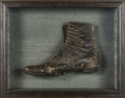
Its sole gouged with holes, the leather top cracked and ripped, the shoe, a woman’s, had been hidden in the west wall of an upstairs bedroom in our Gotts Island house.
Nestled behind the plaster, it had endured Maine winters when the winds howled out of the north, and warm summer days when the bay to the west glowed brilliantly blue. It would have occupied the house alongside generations of families, our own only one in a line that included Gotts and Moores, descendants of the original island settlers.
I know the island, named for its founder Daniel Gott. And I know the house because I have spent every summer of my adult life in it. But I do not know the story the shoe may tell. No one lives year-round on Gotts Island now, the permanent community founded in 1789 having left by 1930. Through the long winter months, when I have returned to my home in California, our house, locked and shuttered like all its neighbors, holds on to the knowledge contained in the shoe.
It had been hiding in the wall for about 140 years, a secret sharer in a house that I thought, at least for the past 50 years, belonged entirely to my family and me. Earlier owners—A.J. Gott, Philip and Vinie Moore—have a reality I can understand. Their passing on the house to us is codified in legal documents. The shoe is different, its possession opaque and somehow the stronger for that.
It is both a witness to history, and a part of history itself. But it is a clouded history as well. In trying to pursue it I would only discover—as with so many other aspects of a small remote island—how much we do not, and cannot, know. This may be the lesson, difficult as it is, that the shoe ultimately has to teach.
Information provided by an architectural preservationist was concrete and direct, inspiring of confidence: “When renewing walls especially around windows and doors…(owners of 18th or 19th century houses) should be aware of the possibility of turning up concealed shoes.” If your contractor finds one, the preservationist cautioned, tell him or her not to throw it out.
This sounded as if people were finding shoes in walls every day. But certainly Adam Sawyer had never heard of it when he was installing new windows and unearthed the shoe in the wall of the bedroom over the kitchen. Fortunately, he did not throw it out. This strange unfathomable presence came into our lives as a kind of ritual object.
On a warm evening in August, my son and his family, my husband, and I gathered ourselves in a circle around an old cane-seated chair on which, like a talisman object, sat the shoe. The aim of the exercise was story making. If we didn’t have any facts, at least, under the power of the object itself, we could imagine its story and how it came to be in the wall.
But imagination is not enough. Once back at my computer in California, I mined Google for still more information on concealed shoes. I learned that in Northampton, England, once a major shoe manufacturing site, similar stories had come to light. In the Northampton Museum resides an index of now more than 2,000 shoe findings, a project begun in the mid-20th century by a curator named June Swann. Most of Swann’s examples came from the UK, but other European countries, Canada, and the United States are also represented. The earliest case is a shoe found in the choir stalls of Winchester Cathedral in 1308.
Interestingly, Swann, who was decorated by Queen Elizabeth in 1976 for her work, found that the number of concealments tended to rise and fall in sync with historical events, rising in times when political or other disruption would have increased anxiety and stress in a community: the Revolution of 1688, or the Thirty Years War in Europe, for example. With this in mind she concluded that the concealed shoe must have been thought of as protecting a building or household against whatever negative forces—political, natural, or supernatural—might threaten it.
But Swann, like other researchers, was never able to find a concrete written explanation to substantiate her theory. Shoes must have sat, unremarked, some for hundreds of years, concealed in chimney spaces, walls, and floorboards. They turned up in humble cottages as well as grand manor houses and palaces, in a Baptist chapel (as well as Winchester Cathedral), in two Oxford colleges, and in hospitals and workhouses.
As for North America, the Society for the Preservation of New England Antiquities has records of more than 100 concealed shoes, the majority in Massachusetts. Examples date from the end of 18th century to as late as 1916, with the larger numbers found in the period 1830-1860. But the most striking to me were the shoe discoveries in Gloucester and its immediate environs—Gloucester was the original home of many of the families, including the Gotts, who were to arrive on Mount Desert Island in the 18th century.
Here were the outlines of a trail, but I had not reached its beginning.
The Gott family represented a pattern. The first Gott to arrive on North American shores with John Endecott in 1628 was Charles, the great grandfather of Daniel, who in 1789 would purchase Gotts Island for 18 pounds. As we know from the work of historians such as David Hackett Fischer, Gott and his fellow settlers would have brought with them not only place names but, more importantly, cultural practices and beliefs they had known in the region they had left behind.
Now I was tracking, if not the shoe itself, the idea that may have given rise to its appearance in our bedroom wall. Like most of the early settlers in Massachusetts, Charles Gott probably came from East Anglia, which, according to the Newcastle index, is the site of many concealed shoe discoveries.
The mindset of those 17th century Protestants poses a challenge to the imagination, but we know they were highly superstitious people. They probably would not have used that term; they would have spoken of “wonders” wrought by God: heads without bodies, animals changing shape, objects suddenly moving by their own agency.
Religion and superstition went hand in hand for these Puritan believers. Witches were as real in Massachusetts as they had been in East Anglia, which saw the greatest concentration of recorded cases of witchcraft in Britain. If we consider that East Anglia is also known for its high incidence of shoe findings, it seems that shoe concealment and belief in witches may have traveled together to the New World, the former, presumably, a protective device for confronting the supernatural power of the latter.
Still, as June Swann had found, a penumbra of secrecy surrounds the practice. Archaeologist Ralph Merrifield, in The Archaeology of Ritual and Magic, notes that no evidence of shoe concealment was recorded by the avid collectors of folklore in the 19th century, even where the practice was clearly still flourishing. The closest Merrifield can come is to call up an “unofficial” English saint named John Schorn, a parish priest in Buckinghamshire, who was famous for his so-called capacity to entice the devil into a boot; hence, to protect the household against witches or other evil presences, one could be advised to place the boot (or shoe?) near a point of entry like a window or door where it would act as a trap. It’s a plausible theory. And it’s a good story too.
But there’s nothing concrete about such stories. And what was true in Britain applies to the United States as well. We have lore involving shoes, but not shoes hidden in walls.

In “Jonathan Moulton and the Devil,” a tale included in John Greenleaf Whittier’s Home Ballads, for example, the central character makes a pact with the devil who appears from out of the chimney and offers to fill Moulton’s boots with gold coins if he places them in the chimney. The story—the deal does not work out for Moulton, of course—includes three elements of possible relevance to the shoe ritual: boots (shoes), the devil, and a chimney (a common location for shoe discoveries). But still, bits and pieces do not add up to a complete picture.
~
The realm of belief, magic, and superstition is difficult to penetrate. We can only try to follow practices that travel in both time and space, undergoing various metamorphoses along the way. The route from East Anglia in the 17th century to a small community on Gotts Island, Maine, in the 19th, is circuitous, even unexpected. It is
never clear.
I was discovering what the Federal Writers’ Project of the WPA (Works Progress Administration) had already found in its 1937 volume on Maine (Maine: A Guide ‘Down East’). In a brief chapter titled “Folklore and Folkways,” it points out that the “comparative isolation and independence of many a ‘down-East’ community have helped to preserve … old customs, beliefs, and legends … that hark back to the Elizabethan times.” These tales of sea serpents, haunted houses, ghosts, and witches had not sprung into being spontaneously. If therapeutic magic practiced throughout Maine in 1937 still was believed to have some efficacy, it also had a long history.
Nor did the federal writers—perhaps thinking back to those early seventeenth-century Protestants?—discount the possible connections between superstition and religious belief: “Every year,” they point out, “serious church-going people attest to the truth of such mysteries and monsters, and an almost limitless volume of material could be gathered about them.”
Itinerant preachers in the 19th century worked to keep religious belief alive and strong on Maine’s offshore islands. The Rev. Lemuel Norton had, for a time, a modicum of success in converting Gotts Islanders to his brand of Free Will Baptists, but it is his description of his arrival on the island, probably in the 1830s, that I find particularly telling.
“When I stepped off the boat,” Norton wrote, “I felt as though I could hardly endure the loneliness of the place.” If religion and superstition go together, as the federal writers suggested, the connection is reinforced by the relative isolation of a community.
In arriving at Gotts Island, Norton stepped ashore on a “beautiful spot of God’s earth,” a place “surrounded by the mighty deep”; but the sea, “mighty deep,” was the real threat—more dangerous than witches—that the islanders, like all coastal people, would have faced.
Understandably, the unpredictability of natural forces, particularly those of the sea, supports superstitious belief. Where livelihoods depended upon fishing, the mythical sea serpents and other creatures that the federal writers heard about most likely represented a response to the dangers, and the fears, posed by the sea itself. Gotts Island’s first Gott, Daniel, and two of his sons were drowned while fishing near Mount Desert Rock in 1814; the small cemetery on Gotts Island attests to how many others met a similar fate.
The sea, the weather, and the currents that determine its actions had to have been inextricably linked to the lives of the intermarried Gott and Moore families who inhabited our Gotts Island house. Susannah Gott’s diary, written in the 1850s, almost obsessively records weather and wind conditions that would have influenced the fishing community and its dependence on the sea. Our house looks westward, out to the sea; the shoe had been hidden by the upstairs window that offers the most encompassing view. It is as if it had been looking out, watching over the safety of the family members who worked that sea.
~
But who could have put “our” shoe in that wall? If I knew that, would I be any closer to knowing why? When I mentioned our strange find to Muriel Trask Davisson, a retired Jackson Lab scientist who now administers the local Bass Harbor Museum, she told me that other shoes had been found in Tremont, the mainland township to which Gotts Island and Bass Harbor belong (I later learned, in a recent article by local archaeologist Anne Grulich, that no less than 14 had been discovered on nearby Cranberry Island). Muriel didn’t have details but remembered talk in her own family of a shoe’s having turned up in the Trask house in Bass Harbor. She said a carpenter named Babbidge had worked on that house.
Here was another thread, this one closer to home. I had a name, perhaps not the right one, but at least a name. On the “Colby Map of Gotts Island” (created in 1879), our house is identified as the home of A.J. Gott, and the closest neighbor, the dwelling immediately to the north, as that of Martin Van Buren Babbidge. The Annual Register for the State of Maine for 1889 lists one M.V. Babbidge, resident on Gotts Island, as “carpenter.” Like A.J. Gott, Babbidge was a man of many occupations (one of which was as undertaker, another as lay minister who performed various marriages on Gotts Island). He had lived on neighboring Swan’s Island for the earlier part of his life, but by 1879, as made clear on the Colby map, he was settled on Gotts Island. I see the house, still there, as a mirror image of ours—at least before ours gained its addition that includes the bedroom in whose exterior wall our contractor found the shoe.
If M.V. Babbidge built or rehabbed a house in Bass Harbor in which a shoe was also found, and if—as seems possible—he was involved in the construction of our addition (or even, according to one theory, moving and putting in place a structure that became the addition), then it seems possible also that it was he who placed the shoe in the wall. He would have been enacting what has been called simply a “builder’s ritual,” a superstition that presumably draws, however tangentially, on the belief that goes back to the 14th century in England.
But who knows, really, whether Babbidge, in any conscious way, was acting to protect the household from some negative fate? Perhaps he wasn’t thinking at all; putting a shoe in the wall was just “something one did.”
Still, despite the unknowns, having the name of a real person (right or wrong) who may have been directly involved in the mystery, lent concreteness to the shoe itself and, even more important, to the woman whose foot is traced in its cracks and creases. Of all articles of clothing, the shoe most strikingly represents the presence, even the spirit, of the individual who wore it. This shoe connected a human physical body to the earth. There is something of the uncanny in our not knowing whose body it was, whose trace we are witnessing. But one thing we know for sure: if there is power embedded in this shoe, it is the power of a woman.
A woman presided over the domestic space of our house, a woman charged with the protection of her family. Beyond the reach of the treacherous sea, so clearly in view from the kitchen window, the house, part of a village that spread in a jagged line along the westward-facing hillside of the island, stood secure.
Here was the woman’s place. Hers was not a household that included non-family members, servants, or slaves (concealed shoes are rarely found in such homes in the U.S.). Whether Gotts or Moores, a nuclear family occupied our house.
On the night our family sat in a circle and tried to imagine the history of the shoe sitting on the chair before us, we were attempting to recreate that woman and her life on Gotts Island in a time so distant from ours. We studied the shape, narrow and slightly pointed—a slim foot it must have been—and we thought that it still retained, despite its desperate condition, a kind of elegance. Yes, it was badly worn, but that is typical of found shoes. Shoes were highly valuable articles of clothing, well taken care of, and intended to last, even for generations. No one would willfully dispose of a good shoe. Perhaps our shoe had been worn only for church going on Sundays, consigned to its hiding place in the wall only after years of wear.
On the other hand, there is a prosaic, almost domesticated quality to the shoe. In a version of a putting-out system, shoes were often constructed, after all, in a domestic space: they belong both in, and to, a house. They knew both the toil of a household and its more celebratory moments.
As for the actual life of the woman who wore the shoe, I expect that I, like June Swann at the Northampton museum, will find no diaries or letters, no specific, real-life, references to who she was or why her shoe was concealed in a wall; and the narrative offered by history, myth, and folklore will always be incomplete. But if our family’s attempts to reconstruct her story were little more than uninformed responses, there are other, more reliable, stories that evoke a local place and provide a more reliable view of the lives experienced there.
Ruth Moore (1903-1989), the most famous member of the family who occupied our house from 1899 until the exodus in 1930, was born and spent her childhood and youth on Gotts Island, and went on to become its chronicler in poetry and prose. Her fictional accounts of life lived in what I envision as my own house in the early decades of the 20th century open up a world that saw power in a woman’s shoe. I see the woman of the family, in whatever shoes she is wearing, standing before the Empress Atlantic wood stove, peering out the kitchen windows to the cemetery down the hill and the ocean beyond, perhaps thinking of family and fellow islanders whose graves she can almost see. Fictions give us individual people who seem “real”: the element that neither June Swann nor I could find in historical theory
or lore.
That Ruth Moore does not write about shoes in walls—probably had no idea that the shoe was there—doesn’t really matter: she gives us a place in which an act like concealing a shoe may have happened. In, for example, The Weir, a struggling family is torn between remaining on the island they have always known or joining neighbors who are leaving to seek a better, and perhaps safer, life on the mainland.
Though the father exerts great effort to support his family and maintain the weir—a netted device strung along a tidal area for catching herring—the major presence in the kitchen, protector of the family order and heart of the house, is Josie, the mother. The men’s territory is elsewhere, a slapped-up structure by the shore to which they repair to socialize, build lobster traps, paint buoys, and store gear and bait—and not be in their wives’ kitchens.
In the words of a local sage quoted in the novel, the men’s gathering spot is “nothing but a damn frig, and the first good gale would blow it down.” A real island house has “laths and plaster and an upstairs and at least two gables, and was built by local labor at the going prices.” Was Ruth thinking of M.V. Babbidge, who would have been still living in her early childhood? This is the space overseen by Josie; this is the house that Ruth Moore knew, the house that a woman’s shoe protects.
Our shoe did not belong to Josie, or, given the time frame, to Vinie, Ruth Moore’s mother on whom aspects of the fictional mother must have been based. I do not know who wore that shoe: perhaps A.J. Gott’s wife Caddie, perhaps M.V. Babbidge’s wife Susan. Or another person entirely. To this degree, the shoe is an object that belonged to itself in its own space; it transcended ownership. And once removed from its hiding place in the bedroom wall to join our world, it became a still different thing, subject to whatever context we wished to give it.
At the end of the summer, our son Chris took the shoe to his home in San Antonio, Texas, to have it framed and preserved. When next we saw it, it was encased in a finely crafted box, affixed to sage green raw silk that brings out the color in the grommets through which the unknown woman would have pulled up the laces.
In a sense, it had been transformed from magic to art. Its “spirit” is now controlled, no longer inspiring the kind of anxiety that I recall feeling last summer. But if this means that something has been lost—and I think it does—I still have a story, or more accurately, stories to tell. And I am comfortable with that.
Christina Marsden Gillis lives in sight of two oceans: in Berkeley, California., it is the Pacific; at Gotts Island, it’s Blue Hill Bay and the islands. With a PhD. in English, Gillis taught and published in the field of 18th-century literature before moving into humanities administration at the University of California at Berkeley.
The Schoodic Story
The Schoodic Story
Peninsula has fueled vastly different visions over the last 100 years
By JACQUELINE WEAVER
Schoodic Point and its acres of pristine shoreline and deep woodlands dodged a bullet more than a century ago when plans by John Godfrey Moore to develop the pristine property were derailed by his premature death.
Moore, the son of a Steuben sea captain, made his fortune in the telegraph industry and on Wall Street. He gained fame in 1893 by successfully suing the U.S. government to stop the new income tax, delaying its implementation by 20 years.
Among Moore’s investments once he achieved great wealth was assembling a more than 2,000-acre estate on the Schoodic Peninsula. His dream for the land included a luxury hotel, grand homes, and a summer resort equal to those in nearby Bar Harbor. The coastal property offered panoramic views across Frenchman Bay to Cadillac Mountain and stunning sunsets from the vantage point of sea-swept Schoodic Point. Among Moore’s great pleasures was standing atop Schoodic Head, from where he could see his hometown to the east.
But those Gilded Age reveries ended when Moore died suddenly in1899 at the age of 51. His family did not share
his vision for Schoodic Point. Visits to the area by his wife, Louise, and their children became less frequent.
In 1922, Louise spoke to George Dorr, credited as the father of Acadia National Park, about adding the Moore property to holdings on Mount Desert Island that had already been set aside as a national park. In the late 1920s, the Schoodic property joined what would later be christened Acadia National Park and represented about five percent of the park’s total acreage.
The two distinct portions of Acadia National Park would become connected in other ways as well, with the relocation of the Otter Cliffs Radio Station. Otter Cliffs was established on Mount Desert Island in 1917 as a strategic listening station for the U.S. Navy. It was considered among the best radio sites along the East Coast because of the lack of man-made noise within many miles and the unobstructed water between there and Europe.
Otter Cliffs could receive signals from Europe when no other station in the United States could. It had been invaluable in World War I when radio receivers were rather primitive. By 1930, the station also began to track weather reports from
Iceland and Newfoundland, and emergency traffic from
Europe, when atmospheric conditions were muddled.
Over the years, the deteriorating Navy buildings at Otter Cliffs became an eyesore. More importantly, Otter Cliffs was in the path of the Park Loop Road planned by John D. Rockefeller and other philanthropists.
The Navy told Rockefeller it would relocate the radio station if a suitable alternative could be found on the coast and within 50 miles of the existing site.
Big Moose Island at the tip of the Schoodic Peninsula and across the mouth of Frenchman Bay was determined to be that ideal location, and an agreement was reached between the Navy, the Interior Department, and Rockefeller.
Rockefeller retained Grosvenor Atterbury, the New York architect who designed Acadia’s gatehouses on Mount Desert, to design buildings at the new listening station in Winter Harbor that would be compatible with those Atterbury designed for the park on Mount Desert Island.
Otter Cliffs was established on Mount Desert Island in 1917 as a strategic listening station for the U.S. Navy.
Atterbury’s plan included a stately hall similar to Rockefeller’s residence at Seal Harbor. That building, along with the adjacent power station, also designed by Atterbury, were listed on the National Register of Historic Places in 2013.
The Navy moved to Schoodic Point in 1935. Its eerie looking Wullenweber Antenna Array and Classic Wizard antennas, dubbed by locals as the “Elephant Cages” for their ring shape and tall antenna poles, worked with satellites to triangulate the location of foreign warships. This also enabled what was later known as Naval Security Group Activity to provide ships equipped with cruise missiles with a means of over-the-horizon targeting.
As the station expanded to meet the demands of World War II and the Cold War, the Navy base grew to 35 buildings and 350 Navy personnel.
By 2001, the Navy prepared to close the base with plans to turn the land back to the National Park Service. The Foc’sle Galley at the facility served its last meal on Sept. 28, 2001. When the Navy officially closed the base in 2002, it was
a major economic blow to the community, leaving vacant housing and dramatically reducing the school population.
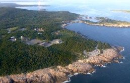
An aerial view of the tip of Schoodic Peninsula.
Photo courtesy: Schoodic Institute
Agroup of interested year-round and summer residents was formed to plan for the future of the property. What emerged from those discussions is what is known today as the Schoodic Institute at Acadia National Park.
Schoodic Institute is the nonprofit partner to the National Park Service, which is charged with operating the Schoodic Education and Research Center, one of more than two dozen such centers operated by the National Park Service across the country.
Don Kent, president and CEO of the Schoodic Institute, said the goal in breathing new life into the former Navy base was always the highest and best use of a property he refers to as “one of the most inspirational natural settings in the country.”
“The National Park Service developed the concept of research learning centers as places where science and education could come together,” said Kent. “The property was deemed a good location for a research learning center.”
A multimillion-dollar investment of federal and philanthropic funds resulted in today’s campus, which offers housing and meals for individual researchers, groups and conferences, classrooms, laboratories, and a modern 124-seat auditorium.
Kent said the timing of the new center could not be more propitious.
“The national parks, local communities, and society face complex environmental challenges that affect our economies, our health, and our way of life,” he said. “Our historical approaches remain relevant, but are at times ill-equipped to produce sustainable solutions.”
Kent said a new approach to solving complex environmental challenges is required, one that encourages collaboration and information flow across the boundaries of natural and social science research disciplines and between research and communities.

David T. Ellwood

Don Kent, president and CEO of the Schoodic Institute
Students and citizen scientists join hands with seasoned researchers at Schoodic Point in examining environmental change, the human response, and how this affects the national parks, communities, and society as a whole. Schoodic Institute’s areas of research include birds, education, forests, marine science, and access to information.
The bird ecology program carries out year-round studies that enlist professional ornithologists, citizens, Acadia National Park visitors, and students of all ages. The forest ecology program focuses on understanding the dynamic natural world and developing effective stewardship responses to global change threats. In the same way, the marine ecology program recruits support from academics to students in understanding the mechanisms driving patterns of change in Acadia and the Gulf of Maine’s dynamic intertidal system.
The new chairman of the Schoodic Institute’s board, David Ellwood, director of the Malcolm Wiener Center for Social Policy at the Harvard Kennedy School, said one driving motivator underlying the research at the Schoodic Institute is a love of Acadia National Park.
“We want to do everything we can to learn about the ecology and environment and the many ways it is changing, and to preserve and protect these natural wonders,” he said. “And we want to engage others in that learning. Importantly, we seek to excite young people about our natural world and the thrill of science.”
Ellwood described the Schoodic Institute as a young start-up doing compelling work and constantly exploring new options.
“We have a unique location within some of the most pristine parts of the park, extending from woodlands to shoreline and into the Gulf of Maine,” Elwood said. “We have a close, dynamic, mutually beneficial relationship with the park.
We have a campus that is well suited to both doing great science and hosting groups of visitors from high school students and educators to scientists and research fellows, to park visitors and many more.”
The challenge, he said, is to attract even more exceptional scientists while recognizing that the research must be circumscribed.

Rockefeller Hall
“We cannot do everything. We must focus on those ideas which take full advantage of our unique assets and add real value to the park and the world. And like most start-ups, we need to establish a stable and reliable economic model.”
Elwood’s interest is personal as well as professional.
“I am fond of saying that my soul resides here,” he said. “Schoodic Institute offers an amazing opportunity to learn so very much about this amazing natural wonder, but equally important is to be at the forefront of introducing the insights of what is happening here to new generations. And in learning and sharing, we have the chance and the responsibility to see what we can do to be effective stewards of this wonderful place.”
Jacqueline Weaver has written and reported for the New York Times, Reuters, UPI and several regional magazines. She lives in Wonsqueak Harbor.

‘Creators in Arms’ on Swan’s Island
‘Creators in Arms’ on Swan’s Island
The two Garys—Hoyle, the painter, and Rainford, the poet—support each other’s creativity.
By Carl Little
Photos by Jack Sullivan
As I walk off the ferry onto Swan’s Island on a cold February day, I am greeted by the two Garys— Gary Rainford, the poet, whose vanity license plate, POETRY, is a tip-off, and Gary Hoyle, the painter.
We head to Atlantic, one of three villages on the island. On the eastern side, Atlantic looks out on Gott’s Island and Bass Harbor. Rainford refers to it as “the Riviera” of Swan’s Island because in the summertime it can be sunny there and thick-of-fog on the other side of island.
The two men are neighbors and close friends; they talk on a weekly basis about their work.
“And if we’re not communicating about art,” Rainford relates, “we’re borrowing tools and materials.” Hoyle notes that the two share “the same kind of creative impulse” that leads one to words and the other to paint.
We start at Rainford’s home, a cozy, sprawling 200-year-old island Cape that is a work in progress. He has made pumpkin muffins and the hot coffee helps take the edge off the chilly day. The family’s rescue poodle, Barney, barks while Gary’s wife Mimi, a special education teacher in the island school, and his daughter, Meri, prepare for a trip off island.
The Poet
Rainford’s route to Swan’s Island was circuitous. Born in East Meadow, New York, he was bitten by the travel bug while still a teenager. When his mother asked what he wanted for a high school graduation present, he didn’t hesitate: a one-way ticket to Los Angeles.

Gary Rainford in his writing nook.
Staying at an aunt’s home in Thousand Oaks, she encouraged him to take a few classes at Long Beach City College. Hooked, he transferred as a junior to the State University of New York at Stony Brook, near his home, and then returned West for grad school at California State University, Sacramento.
On a motorcycle trip up the Oregon coast, Rainford stopped in Bandon on Coos Bay.
“I landed there because it was raining and I knew there was a hostel.” He met his future wife, Mimi Bell, who was from New Hampshire and had family ties to Maine. At some point his mother sent them a copy of Yankee with an article about how Cliff Island in Casco Bay was wooing young people interested in a non-traditional lifestyle and starting a family—“Looking for breeders,” is how Gary puts it. With that seed planted, he and Mimi returned East with the idea of living on an island fixed in their heads.
By then, Rainford had a teaching degree. The couple moved to Rochester, New York, where Gary got a job at Monroe Community College. He still teaches there, via the internet—composition, introduction to literature, and creative writing.
Every chance they had, the pair went to the coast.
They got engaged on Vinalhaven. They arrived on Swan’s in 2001 when Mimi landed a job at the island school. Unable to find long-term housing, they moved to Seal Cove on Mount Desert Island.
Not a week later, Jay Wheaton, a member of the same family from whom Gary and Jeanne Hoyle had bought their land, called to say his mother was ready to sell. The Rainfords felt honored—the community wanted them to stay.
Gary started writing poetry when he was a kid. He recalls “drawing with words in his head” while hospitalized for asthma in sixth grade. Later, in California, he discovered books by punk rocker-turned-poet Henry Rollins and countercultural writer Ken Kesey. He also embraced the writings of Charles Bukowski and Robinson Jeffers, writing his thesis on the latter poet’s philosophy of inhumanism.
Rainford’s first collection of poems, Salty Liquor, (2014), is largely inspired by Swan’s Island and being a stay-at-home dad for his daughter. His second book, Liner Notes, (2017), shifted gears, offering responses to concerts, some he went to and others he found on YouTube. He pays tribute to a wide range of musicians, from Elvis and Ella to Motorhead and Elvis Costello.
“My goal as an artist and poet is to break down whatever it is that makes poetry—including just saying the word ‘poetry’—scary to people, to defuse it and bring more people to the experience,” Rainford says. He is currently working on a new manuscript, Seven Springs, inspired by a year of taking care of his mother as she struggled with onset dementia. Last year he moved her from Florida to a senior living home in Bangor where she now lives.

Rainford’s vanity plate
Rainford’s contributions to the cultural life of Swan’s Island range from annual poetry readings to the twice-a-month workshops he leads through Swan’s Island Writes. He has organized a poetry residency with Friends of the Swan’s Island Light, hosting award-winning poet Terese Svoboda in 2018. He also serves as co-editor of The Island Reader, the annual anthology of island writers and artists published by the Maine Seacoast Mission. He edits and produces the collection through Island Verse, Inc., a micro-publishing press he launched in 2016.
The poet is also, it should be noted, code enforcement officer and the local plumbing inspector on Swan’s Island.
“I reluctantly took it on because I felt it was community service, with my daughter growing up here,” he explains.

“We did a lot of experimenting with materials. It was like play time!”
“I have to do the state trainings with other inspectors and CEOs, and it’s a different world from academia.”
In the winter, Rainford gets up at 4 a.m., fires up the woodstove and writes on his computer until his family rises a few hours later. In the summer he has a writing nook on the second floor.
“I live the life that I really wanted when I was younger, to have a flexible schedule so that at any point I can work, write.”
The Painter
Gary Hoyle’s path to Swan’s Island also had some twists and turns. He was born and raised in Gardiner, where his father worked in a shoe factory and his mother was a homemaker. His love of nature was nurtured while exploring the 1,500-acre Gardiner Estate just down the road. He also recalls going up Cobbossee Stream with his grandfather and finding snapping turtles among the boulders.
After completing a zoology degree at the University of Maine, Hoyle started a master’s program, but was uncomfortable with the prospect of becoming a scientist. He taught for a while, then took a job as research associate at the Maine State Museum. Mentored by Fred Scherer (1915-2013), who painted some of the best-known dioramas in the American Museum of Natural History in New York City, Hoyle became curator of natural history, designing and fabricating a significant portion of the museum exhibits over his 28-year tenure.
Challenged to create something artificial that looks real, Hoyle became a master of illusion.
“We did a lot of experimenting with materials,” he recalls. “It was like play time!”
He also enjoyed the research his work entailed, such as going to North Haven at the suggestion of museum archaeologist Bruce Bourque to find wild currant berries and plants to guide his remarkable waxwork recreation of native edible plants.
A fellow staff member at the museum, archivist Ed Wheaton, talked up Swan’s Island and invited Hoyle and his wife Jeanne to come out for a visit. The couple liked what they saw and bought a small cottage in 1985. A few years later they purchased a piece of land on the other side of the island and hired a crew to move the house. They eventually sold their home in Pittston and moved year-round to the island in 2007.
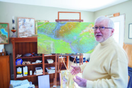
Hoyle and one of his marbelized
landscape paintings.
Hoyle served as artist in residence at the Climate Change Institute in Orono in 2008. While there, he created a Gary Larsen-esque cartoon series to help explain global warming to young people. In the story, kids find a talking mammoth in a gravel pit and watch as it struggles to adjust to current climate conditions. At the end of the story, the kids shave the creature.
Hoyle has also painted “dinosaur fantasies” over the years, humorous takes on how various species of ancient reptiles might come in handy today. He continues to create museum displays, including remarkable life-like turtles, one of which will be in “Focus on Nature XV: Natural and Cultural History Illustration,” opening in July at the New York State Museum in Albany.

Hoyle at age 15 in 1960 presents two of his sculpted turtles to then-Governor John Reed, left, and museum curator Klir Beck for the Maine State Museum. Beck had seen Hoyle’s work and asked him to sculpt the turtles.
While officially retired, the Hoyles are busy. Last year Jeanne became executive director of the Swan’s Island Educational Society, which encompasses the library and historical collections. They spend time with family.
Hoyle spends most of his time painting. A watercolorist like his father, he began to work in oils with guidance from his mentor, Scherer. Some of the work appears in the acclaimed “Made in Maine” exhibit at the Maine State Museum.
In recent years, Hoyle has developed a marbleizing technique whereby he floats colors on turpentine and “picks them up” on canvas to create stunning vistas that resemble aerial landscapes. He is showing paintings in Rockland this summer with Jordan Chalfant, a natural history artist he mentored at College of the Atlantic.
Thanks to his neighbor, Hoyle has also become an engaged writer. Rainford has been helping him with a book that recounts digging up a mammoth skeleton in Scarborough in 1992-1993. Hoyle is interweaving the mammoth story with another concerning P.T. Barnum and the elephant that inspired him to create The Greatest Show on Earth.
“We’re not just painters and writers,” Rainford says. “I see us more as creators.”
He notes that both rebuilt their island houses, approaching the task with ingenuity and imagination. Hoyle agrees. Both are problem solvers, adept at finding the right word or color to complete a poem or painting. It’s a mutual admiration society of two men devoted to family, art, and their island community.

Carl Little lives and writes on Mount Desert Island. His most recent books are Paintings of Portland, co-authored with his brother David, and Philip Frey: Here and Now, co-authored with Daniel Kany.
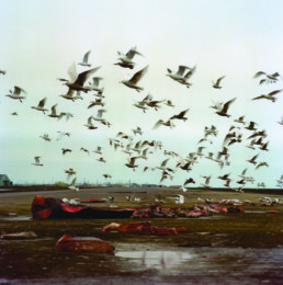
Nantaska: The ‘Islands’ of Nantucket and Alaska
Nantaska: The ‘Islands’ of Nantucket and Alaska
A surprising commonality around tourism and resource extraction.
By Crocker Snow Jr.
The tiny northeastern seacoast island of Nantucket, 43 square miles, and the giant, “Upper 49th” state of Alaska, 663,237 square miles, are about as dissimilar as could be. They don’t share the same boarding house at all geographically, demographically, economically, and culturally. Yet the two lands, cherished symbols of pristine seascapes, landscapes, and rugged individualism, share some curious similarities. The drive of their peoples, their self-image, and self-conceits are mirror images of each other.
The inhabitants of Nantucket and Alaska—or, as I call them, “Nantaska”—are proud of their “otherness,” their lifestyle, hardships, and heavy weather, and of the sentimental place their homelands hold in the minds of many absentee Americans. Many who have planted a stake in one place or the other share the same inner conflict of soaking in the natural beauty while working it to its fullest.
Whether in resource extraction or tourist promotion, similar social tensions characterize the two lands. The push-pull between conservation and exploitation, between preservation and development, are stressers in each place.
“It’s being at once removed, of being on the periphery, of being acutely subject to, and daily influenced by the whims
of nature,” says Nantucket resident Pete Howell, who shed his international banker life 20 years ago for the appeals of island life.
A similar sentiment drove a New Englander north and west. “It was the convergence of migrants and natives when all wanted to be close to the land,” recalls Jennifer Johnston of her move from Vermont to Anchorage in 1975, and her range of activity since as a ski instructor, survival trainer, and now a member of the state legislature in Juneau.


It may be more than coincidental that state abbreviations and aeronautical charts show only one capital letter separating Alaska and Nantucket—AK and ACK. Maybe some heavenly scribe or geographer had some of the close connections in mind.
Alaska and Nantucket both come from Indian names. The former was initially called “Alakshak” by the offshore Aleut islanders, meaning the “Great Country” well across the waters. Nantucket comes from the Wampanoag tribal name of “Nantocke,” meaning “in the midst of waters” or “faraway land or island.” Both places are separated literally and figuratively from the Mother Ship of the 48 states: Nantucket by 28 briny miles of Nantucket Sound, and Alaska by the 750 miles from its closest U.S. neighbors.
As it happens, it was a very big fish, technically a sea mammal, that first tied these disparate places together.
In 1848, when whaling was still the sine qua non of Nantucket’s prosperity, the most intrepid captains pioneered ever farther in search of the prized sperm whales, first around Cape Horn to the Galapagos, Hawaii, and eventually to Alaska. There they encountered Inupiaq hunters in open boats harpooning smaller bowhead whales, mostly to boil and eat for sustenance. The two hunting cultures communicated, cooperated, and intermarried around Barrow, Alaska between the Beaufort and Chukchi seas on the North Slope.
Today, Alaskan natives, having reclaimed the original name of “Utqiagvik,” are still allowed to cull some whales, and the descendants of Nantucket families such as Coffin, Leavitt, Cottle, Fischer, Jernigan, Pease, and Tilton still reside there.
Just as stories of the whale were critical to an early “meet and greet” between Nantucketers and Alaskans, so, too, were the parallel patterns discovered by subsequent generations in the 19th and 20th centuries. Resourcefulness and a can-do approach carried on in each place, from the Gold Rush in Alaska to offshore trading and onshore shellfishing in Nantucket.
The special environments prompted the flowering of creative arts. Fine writers like Herman Melville with Moby Dick and Jack London with Call of the Wild depicted the hardships and story-telling lifestyles of each place, and these traditions were carried on by worthies like Margaret Murie, James Michener, and John McPhee highlighting Alaska, and, currently, Nathaniel Philbrick’s Nantucket.
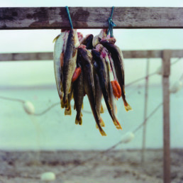
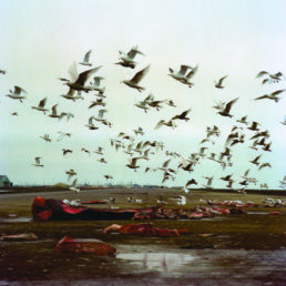
Fresh Challenges: Climate Change
Alaska is moved by the heavens and Nantucket by the seas. Each place is experiencing climate change ramifications in ways as visible and extreme as almost anywhere in the world.
Like many coastal communities, “Nantaska” and its inhabitants are affected by the warming and rising seas triggering coastal erosion at an accelerating rate. In Nantucket, climate change was experienced most visibly in 2013 when the island’s famed, 150-year-old Sankaty Lighthouse had to be moved 400 yards inland from the rapidly collapsing bluffs on the island’s northeastern headlands. The 500-ton lighthouse was kept intact as it was moved over temporary railroad tracks lubricated by whale oil.
In Alaska, some of the first signs of climate change were seen in animal behavior: polar bears having to swim farther to find seals to hunt on disappearing icecaps, walruses traveling greater distances to find isolated rocky beaches on which to haul out. Such wildlife changes have been harbingers of tilts in Alaska’s ecological balances. Along the exposed North Slope, small native villages are slowly succumbing to the sea. Shishmaref and Kivalina on Alaska’s Arctic Coast are the poster children for this as their native populations face relocation inland.
As Alaska’s ice caps and glaciers thaw and the sea rises, the amplification effect grows. Scientists explain this as “ice-albedo feedback loops,” highlighted by diminishing white ice to reflect the sun’s rays and more dark seas to absorb them.
This makes the air and the waters warmer still. The melting of permafrost and the escape of methane gas blooms into the atmosphere are happening apace.
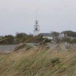
Fresh Challenges: Tourism
Tourism is a critical and ever-growing ingredient for the Nantucket and Alaska economies. Day trippers or vacationers fill the ferries to Nantucket during the summer months, when the island population balloons from 17,000 to 45,000. Creating crowded streets, restaurants and beaches, but also the island’s real estate rain-maker, they are welcomed by many in a sighing, roll-your-eyes way.
In the vast areas of Alaska, the tourist effect is less obvious. The mammoth cruise ships that ply the inland seas from Juneau up to Anchorage and parades of RVs heading for Denali Park and beyond, are the most visible symbols of this.
In both places, the hospitality industry represents an ever-larger piece of the economic pie. It is far and away the top moneymaker in Nantucket, and second or third behind only oil and gas, and ahead of mining and fishing, in Alaska, according to the respective chambers of commerce.
So what’s to be done about it? One thought of this regular visitor to, and admirer of, each place is to double down on tourism by loudly promoting eco-tourism.
“Nantaska” has no Las Vegas appeal to the visitor. It’s not glitzy. Visitors come to experience the scene more than be entertained by it. They buy mementos reflecting what they see and which remind them how they felt about it. Both places could highlight their comparative “beautiful nature” advantage in a more disciplined and fulsome way. Both could nourish ecological, environmental, and educational tourism as their blueprint for the future.
Nantucket and Alaska first connected hunting whales some 230 years ago. Whaling was a bloody business, but it helped provide food, light, and lubrication—and so, like the buffalo, whales were overhunted to near extinction. Happily, needs have changed. In this time of climate change and environmental deterioration, what a worthy goal for “Nantaska” people to connect again, this time aiming for “best of breed” in green and eco-tourism. It could be the tantalizing, hard-to-reach, virtuous feedback loop.
Crocker Snow Jr., a journalist from Ipswich, Mass., has long visited and observed Nantucket and Alaska through family, friends and as a matter of professional interest. His book Nantaska: the Minnow and the Whale: The Curious Parallel Lives of Nantucket and Alaska, with photography by Brian Adams, was published in June 2018. It is available at independent book stores in both places and via the author: crockersnowjr@earthlink.net.

Taking Stock of a Downeast River
Taking Stock of a Downeast River
History, heritage, and commercial viability of the last smelt run hang in the balance.
BY JON KELLER
Five degrees above zero and the wind peels northwest. Sky and river both black dark. Headlights shine in the small parking lot. The wind howls, rocks the truck. Out there in the headlight shine lies a slick mud bank and a river of churning brown water.
Bobby Beal’s at the wheel. He’s a local clam digger and lobster fisherman and tuna fisherman; a hunter and trapper and taxidermist and registered Maine guide.
If there’s an animal that needs to be tracked, caught, trained, tamed, saved, or killed, Bobby is the man to do it.
With him is Dwayne Shaw, the executive director of the Downeast Salmon Federation (DSF), a grassroots conservation group that he’s headed since its inception in the early 1980s. A mix of mountain man, fisherman, redneck, hippie, and environmentalist, Dwayne may very well know more about the waterways that lace the coast of Maine between Bar Harbor and Canada than anyone.
“Cold out there,” Bobby says.
The heater’s on full blast and inside the truck has to be over 90 degrees.
Dwayne laughs. “But it’s a good smelt tide,” he says.
I lean back in the truck seat, watch the water roll by, the streaks of wind flipping wrinkles of wave and skating piles of dark foam across the water and mud, both. The arm of the river in front of us—the West Branch of the Pleasant River—is dammed by a clapper that allows water to exit but not enter, thus destroying what was once a tidal estuary teeming with life. Not good, Dwayne says, for smelt, and he and the Downeast Salmon Federation have been lobbying for years to remove the clappers, but thus far to no avail.
The main branch of the Pleasant lies to the east, an exposed corridor sided by long stretches of treeless marshlands that flood with the full and new moon tides.
It’s dark now, and we can see little of the river, only feel the wind that howls over the icy marshlands, the water riotous, the waves bristling and breaking.
We untie the boat and flip it to the ground before the wind can take it. Bobby and I drag it over the riprap and down the smooth, hard mud. It’s half tide, and the seawater presses upward against the river fall.
We load anchors and gillnets into the canoe. Dwayne hands a spotlight to Bobby and says, “Don’t forget to rescue us if we flip.”

Dwayne Shaw
Photo: Leslie Bowman
“I’ll just get in the truck and put the gas to the floor. She’ll make it far enough for you to touch your toes on the roof, anyway.” He laughs, just a little. “That way we’d all be drowned.”
It’s a joke, but not a joke. In two separate incidences, decades apart, Bobby lost four uncles, his father, and his grandfather to the neighboring Harrington River—the river he and his brother and sons and daughter and son-in-law and grandsons all make a living on as clam diggers and lobster fishermen, the river his mother’s house looks out upon; all of the drowned men had been on their way home from digging their day’s clam tides when their skiffs overturned in the cold, fast water.
Dwayne and I push off. The idea is to set all three nets in the 100-yard stretch of the West Branch that runs from the clapper dam to the confluence with the main stem of the Pleasant River. Dwayne sits in the bow and works the nets, tells me where to go. Bobby stays on shore, working the spotlight. The mud banks are dotted by the remnants of wharves and pilings, evidence of the shipbuilding that dominated the river in centuries past, back when this was a town bustling with people and commerce.
A streetlight glows on the few homes that make up the current village of Addison, just across the West Branch from the parking lot. At the light’s edge, the derelict shape of what was once the town’s clam shucking house looms atop the mud bank, sided by ages of clamshell midden.
We nose against the tide. Dwayne drops an anchor and begins working the net out as we back. When the net goes tight, he drops the second anchor and buoy. We do this two more times, laying out all three gillnets with the current, an anchor and buoy marking each end of each net so that if you were to see them from above it would look like the raking of a three-toed claw.
Several miles up the main branch of the Pleasant River stands the town of Columbia Falls, and the head-of-tide pool into which the namesake waterfall tumbles. The pool is circular, roughly a half-mile across; the wedding place of fresh and salt water. Above the pool and falls, the Pleasant River runs fresh and brown with tannins, an artery pumping out of a sprawling heath watershed of oak and red maple; below lies salt marsh and tidal waters and ocean.
There was once a small hydroelectric dam blocking the waterfall, but the dam is gone and all that remains are remnant fractions of concrete, the failed fish ladder, and the building that now houses a portion of the Downeast Salmon Federation’s facilities, including its former salmon hatchery. A state of the art facility in nearby East Machias holds the DSF’s new, high-tech hatchery, together with a host of additional offices.
Since the DSF began in 1982, it’s grown from three dedicated people trying to lend voice to Downeast Maine’s struggling Atlantic salmon population into a thriving network of a dozen full-time employees and a host of volunteers and communities fighting for rivers and salmon and public lands; and the DSF’s fight has gone well, with nearly 3,000 acres of waterfront land and 23 miles of streams and rivers conserved—not bad for a small town, grassroots group operating in one of the poorest counties in the nation.
The truck idles. The heater blasts. Bobby turns to Dwayne and says, “Think we’ll catch any smelt?”
Dwayne rubs his beard, doesn’t answer.
“Sewell’s stories were glimpses at the history, the culture of the river, the interaction of the people and the water…”
Finding out where the smelt run is exactly what Dwayne’s been doing, and what Bobby and I have been helping with. The Pleasant River is home to the last commercial smelt gill-net fishery on the eastern seaboard, and that fishery takes place exclusively in the head-of-tide pool just below the old hatchery and clock tower. In the lee of the colonial homes of Columbia Falls, a row of small tarpaper fish shacks hugs the pool’s eastern shore, each with a small, crude deck and a similarly crude wood stove. The shacks have been there for generations, and have been used each spring by the last of the smelt fishermen—a school principal, an oil truck driver, a disabled war veteran gone poacher, a man dying of cancer who could barely walk or talk but nevertheless maintained his nightly smelt vigil.
It’s a nocturnal fishery, and the tides have to provide a high tide in the dark of night. The nets are set on the rising tide in order to fish through the high water, then they’re hauled on the outgoing tide. When the tide is right, the fishermen pile their nets into their skiffs and drag the skiffs down the gravel to the water’s edge, row out and set the nets in the pool, then return to their smelt shacks to talk and nap, drink and smoke, until it’s time to haul the nets back up.
The tide creeps up the gravel banks, floats the skiffs that lie tethered to trees or posts, laps at the shacks’ decks and front steps, nearly floods floors on a full or new moon tide, then recedes. A couple hours after high water, the fishermen stand from their wood stoves, bundle into warm clothing, and again row out into the darkness, the clock tower shining above them, to haul the nets that are hopefully stuffed with shining and flipping rainbow smelt.
Why the Pleasant River is such a viable, healthy smelt fishery—with neighboring rivers not producing anywhere near the numbers—is about the pool that’s been created by the falls, and about the tide that comes flushing in twice a day, its nutrient-rich currents meeting the river’s own nutrient-rich currents; it’s about the salt and tannic waters mingling, swirling, stirring.
Unlike surrounding rivers, the Pleasant River’s head-of-tide pool has a gravel bottom on which the female smelt drop their roe; they’re the first round of smelt that the fishermen see, followed soon after by the males, heavy with the milt that’s released onto the eggs. Each spring, the pool becomes a frenzy of reproduction; the currents mix the eggs and sperm as if in a great cauldron, and the fertilized eggs drop to the gravel bottom—as opposed to the ubiquitous mud and clay bottom found in neighboring rivers—protected between individual rocks.
Dwayne’s a salmon guy, but more than that, he’s a fish guy, especially an anadromous fish guy, and since his office overlooks the falls and pool and the row of smelt shacks, he’s interested. He’s a river man, and if one is interested in a river—truly, deeply interested—that interest will inevitably land upon the cultures the river supports, from the long-ago native smelt fishermen to the current band of local shack fishermen.
Over the last handful of years, Dwayne and Bobby and I have spent spring nights sitting by the wood stove with the Pleasant River’s senior smelt fisherman, a wounded Korean War veteran and renowned (i.e., reputed) poacher named Sewell. Sewell was a talker, and when his head wasn’t back and his mouth open with snores, he’d talk about catching smelts as a child, back when the train came through Columbia Falls, and they’d pack the fish end-for-end in wooden boxes for shipment to Boston.
We’d hear about years when the river stayed frozen so long that they’d fished their nets through holes in the ice, stories about the waterfall teeming with salmon, about the old generation knitting their own gillnets; stories about poachers and wardens and skirmishes and men whose lives revolved around that river, that run of fish. Men like himself.

Sewell Look, left, and Dwayne Shaw
Photo: Leslie Bowman
Sewell’s stories were glimpses at the history, the culture of the river, the interaction of the people and the waterway, good and bad, and Dwayne listened. He cared. Cared about the fish and the river and the people along the river.
In 2004, other regions on the eastern seaboard realized population declines or even river-wide extinctions (mostly caused by the perpetuation of dams with inadequate fish passage), inciting the National Marine Fisheries Service to list the anadromous rainbow smelt as a species of concern, and the Maine Department of Marine Resources decided to shut down the commercial gillnet smelt fishery.
Few would have noticed the closure; it’s a small, isolated, quiet, fiscally worthless fishery. But Dwayne noticed. He cared about the fish and about the culture surrounding the fishery, and since scientific understanding of rainbow smelt and their habitat was lacking, he offered to work with the DMR to find out if—as he believed—the Pleasant River’s anadromous rainbow smelt fishery was indeed viable. In addition, DSF would work with DMR to develop a framework for ongoing management and conservation.
Although DSF would be the major facilitator of the smelt research, the small group already had its hands full and a budget strapped by its conservation projects. So Dwayne used mostly his own time—and that of volunteers like Bobby Beal—to collect the data. And that time came in late nights, eating gas station food, driving river to river along Downeast Maine’s unlit byways with a canoe and a truck bed full of smelt nets; headlamp scrambles down riprap river banks and bridge abutments when everyone else was home in bed; early mornings sampling fish, eating cold pizza, and drinking to-go coffee, logging data, evermore data.
He’d talk about catching smelts as a child, back when the train came through Columbia Falls, and they’d pack the fish end-for-end in wooden boxes…
From 2012 to 2018, Dwayne and DSF worked with DMR to survey 90 coastal rivers and streams in Washington and Hancock counties, and Dwayne canoed his gillnets into many of those waterways to learn first-hand what numbers of smelt were moving upstream, thus proving to the state that the Pleasant River was in fact an anomaly, that it could support the small-scale localized commercial fishing that it received.
The idea, if unspoken, was that the perpetuation of the culture that appeared to have no young recruitment was worth the hundreds of pounds of smelt that were landed each year—a drop in the bucket compared to the biomass the river supported.
Ironically, the local Pleasant River fishermen Dwayne was trying to help were his largest critics; not only was he trying to prove to the state that these guys weren’t hurting the river and the fishery, he was trying to prove to these guys that he wasn’t the one at fault for the regulations they were facing. To many of them, a scientist was a scientist, be he or she federal, state, or local.
The DSF, its small office building looming above their smelt shacks, represented science and regulation and change, a breach in the way things had always been done. No matter that Dwayne, with his thick beard and calloused hands and working-man’s frame, looked like any one of them; never mind that he’d sat night after night, year after year, in their smelt shacks, drinking beer and listening to stories; never mind that he’d accepted them, accepted their tales of poaching and misconduct; never mind that he was, literally, the only thing standing between the fishery they loved and the guillotine regulations that were headed their way.

In a “fake news” sort of manner, a scientist in charge of a conservation group standing up against regulations didn’t compute, didn’t add up, so every once in a while, when one or two of the more ornery fishermen drank too much, he’d lash out at Dwayne and the DSF.
Dwayne would smile, glance at Bobby and me, laugh his customary laugh, and with the same nonchalance he could incorporate when giving a presentation to a ritzy salmon fishing organization, he would say something like, “Yeah, us environmentalists, ruining all the fun, trying to keep you guys in business.”
That would be as far as it would go. Despite the orneriness, despite the bitterness that might well-up in the face of intangible change, the fishermen were small-town men who truly cared, and there was no arguing the fact that the Downeast Salmon Federation was a different breed of conservation group: it was a group of fishermen, back-to-the-landers, hunters, environmentalists, conservatives, liberals, rednecks, retirees—you name it—but what every one of them had in common was a love for Downeast Maine’s rivers, coasts, and communities.
Bobby and Dwayne and I sit in the truck several miles downstream from the pool and its attendant smelt shacks, watching the river, the heater blasting. We talk about the other rivers Dwayne has set nets in: the Narraguagus, the East Machias, the Dennys, and he’s found few, if any, smelt in any of them.
“Cuz it’s too damned cold,” Bobby says with a laugh.
High water comes and goes. Out there in front of us, the gillnet buoys dance between the wind and current. I gaze at the old Addison clam shucking house on the far bank, a glimpse at a time gone by, a time when resources were inexhaustible, when humankind was too small to harm the planet. Now, in that truck, I wonder if humankind is capable of helping the planet, fixing the damage caused.
We sit for perhaps another half hour, then slide the canoe
down through the mud and into the water. Slowly, carefully, we haul one net at a time, Dwayne standing in the bow of the canoe, flaking its icy lengths into a fish tray. The wind howls, presses against the canoe. Now and then, Dwayne tosses a stick aside, but he finds no fish. Not a single one out of 150 feet of net.
We load the truck, look out at the clapper dam that blocks the saltwater from rising any further up what was once a healthy tidal river. “The old folks,” Dwayne will later tell me, “remember smelt nets all the way up the West Branch, back before the clapper dam.”
That was all a few years ago now. The old poaching smelt kingpin, Sewell, has died; Louis, the fisherman with throat cancer, has died. The men who fished with them have taken over their licenses, their smelt shacks, and so each spring, the wood stoves still pump smoke through the nights, and the men still drag their skiffs down the gravel bank in order to set their nets in the darkness as the falls fill the night air with their sound, the old clock tower still aglow above it all, glimmering in the pool.
Not much has changed. The DSF took over the lease on a derelict smelt camp, and built its own camp, which serves as both a working smelt shack and an interpretive center for students, tourists, and community members.
Time blurs. The interpretive smelt shack is set in the row of functioning smelt shacks, and although Dwayne’s research did what he’d hoped it would do—he proved that the Pleasant River could support the East Coast’s only commercial gillnet smelt fishery, thus keeping it open—the end seems to be nigh. Whether it’s because the fishermen are aging, or that the smelt shacks are falling into insurmountable disrepair, or that the state will inevitably end the fishery, nobody truly knows.
But for now, what exists in Columbia Falls, and what DSF has helped create, is a merging of past and present in order to, hopefully, benefit the future of the river that binds people and place together. Late at night, men go out in skiffs and fish the antiquated fishery, and while they sleep the following day, local students gather only yards away to learn how it was once done.
Jon Keller lives in Addison, and is the author of the novel Of Sea and Cloud, set in a Downeast fishing community,.

Folio: Othered
DANIEL MINTER
Othered: Displaced
from Malaga
Excerpted from an exhibition and catalogue featuring paintings produced by Daniel Minter’s artist-in-residency at the University of Southern Maine, Gorham, in late 2018.
Daniel Minter uses his art as a tool for dialogue with his community. He is the co-founder and creative visionary of the Portland Freedom Trail, a system of granite and bronze markers that constitutes a permanent walking trail highlighting the people, places, and events associated with the anti-slavery movement in Portland. Minter’s work also marks the Malaga Island Trail commemorating the Black, European, and Native American residents of the island who were forcibly removed by the state of Maine in 1912.
Minter’s paintings, carvings, block prints, and sculptures have been exhibited both nationally and internationally at galleries and museums, and he has illustrated 11 children’s books, including Step Right Up; How Doc and Jim Key Taught the World about Kindness, and Ellen’s Broom which won a Coretta Scott King Illustration Honor; Seven Spools of Thread: A Kwanzaa Story, winner of a Best Book Award from the Oppenheim Toy Portfolio; and The Riches of Oseola McCarty, named an Honor Book by the Carter G. Woodson Awards.
Learn more: www.danielminter.net


The Story of Malaga
By Kate McBrien
For years, the story of Malaga Island was buried, lost to history and denied by the few who lived it. But today it is a story told repeatedly among families, schools, and communities. It is a story to learn from and remember.
In July 1912, the State of Maine evicted the multi-racial group who called Malaga Island home to clear the small coastal island of “It’s Shiftless Population of Half-Breed Blacks and Whites,” as one 1911 newspaper article described it. Today we know so much about this island’s history due to the notoriety of the community. Because they were different, and visible, many myths quickly grew about this secluded, mixed race community. Consistent with racism in Maine at that time, stories about theft, inbreeding, and illiteracy spread across the nation through newspaper and magazine articles as well as postcards. Christian missionaries who worked on the island documented and spoke about the people who lived there.
Reality was quite different, however. Families struggled to meet their basic needs but built homes on the small island off the coast of Phippsburg, Maine, educated their children as much as possible, and interacted with the mainland community peacefully and as needed. A rapidly changing economy severely influenced the lives of the Malaga Island residents early in the 20th century. During the late 1800s, Maine experienced a decline in its dominant ship building industry at the same time as a serious decline in fish stocks. As jobs disappeared, more and more people like the residents of Malaga turned to their towns for financial assistance. Most coastal towns looked to tourism as the new industry that would save the coast of Maine.
At the same time, the Eugenics Movement began to thrive in America at the turn of the 20th century, adding to the already existing racism and driving social and state-sponsored practices aimed at breaking up communities and families. The eviction process for the island community, as documented by the State of Maine, shows evidence of this consistent following of eugenics theories and the overall belief that those living on the island were degenerate or immoral. In 1905, the Island residents were made wards of the State, managed by the state’s Executive Council.
In 1911, George Pease, the assigned overseer of care for the Malaga residents, submitted a report to that Council with his recommendations for what should be done with people on Malaga Island. The report uses difficult, racist terminology to describe the various families living on Malaga Island. In his report, Pease described the race, health, and his opinion of the work ethic of individual Malaga Island residents. He then made recommendations for eviction, with no help for finding new homes. Some, he suggested, should be institutionalized in the Maine School for the Feeble-Minded. While not all his recommendations were followed, many were.
In the Reports of the Committee of the Council for the State of Maine (1911-1912), an entire section is devoted to Malaga Island. The report states: “There has been heretofore, and some are existing at the present time, certain pauper colonies that have been for years a disgrace to the adjacent communities and a blot upon the State. We refer particularly to Malaga Island, Athens, and Frenchboro.” The report described the decision to evict the islanders this way: “After viewing conditions it was decided at a Council meeting shortly after, that the good of the State and the cause of humanity demanded that the colony be broken up and the people segregated….” To prevent further “squatting” the State decided it should hold title to the island.
On December 9, 1911, a local doctor and member of the state’s Executive Council signed papers committing Anna Parker and the entire Marks family to the newly formed Maine School for the Feeble-Minded at West Pownal, Maine. When Agent Pease arrived on the island on July 1st to evict everyone, he found the island deserted. All houses had already been removed or dismantled. The remaining residents of Malaga Island scattered to nearby towns, setting up home where they could. Some found available space in the Sebasco area of Phippsburg, others went to Cundy’s Harbor, Brunswick, or Bath. Today, Malaga Island is a nature preserve, owned and maintained by the Maine Coast Heritage Trust.
The University of Southern Maine Art Gallery produced a stunning catalog of paintings and essays on the history of Malaga island and Daniel Minter’s body of work during his residency. Available online: usm.maine.edu/gallery.